Name/Title
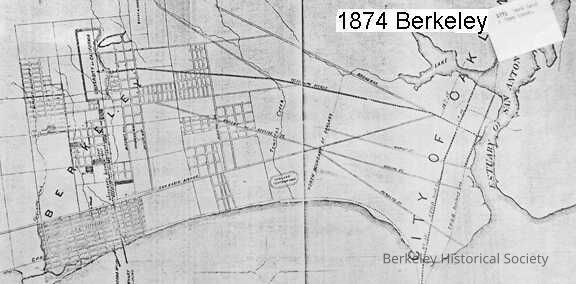
Map of Berkeley showing the property of the Berkeley L.T.I Association.Entry/Object ID
1978.043.024Description
Berkeley Land and Town Association.
Shows highlighted property west of San Pablo Avenue, from approximately Bancroft Way north to Codornices Creek.
Coverage of map extends south to Estuary of San Antonio, City of Oakland, but with only a few streets indicated.
Shows location of Haywood & Jacobs Wharf.
3 copies: original torn at fold and damaged at top; two reproductions, one mounted on boardLexicon
Nomenclature 4.0
Nomenclature Secondary Object Term
MapNomenclature Primary Object Term
CartographNomenclature Sub-Class
Graphic DocumentsNomenclature Class
Documentary ObjectsNomenclature Category
Category 08: Communication ObjectsLOC Thesaurus for Graphic Materials
"Maps"Search Terms
"Berkeley Land and Town Association"Dimensions
Dimension Notes
11 3/4 x 16 3/4 in.Location
Other
Drawer FB-5, Folder 5f