Name/Title
Print, PhotographicEntry/Object ID
2013.1113.5.12Description
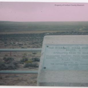
Color photograph and replica color slide (John McCormick photographs). Photographed is a landscape, metal railing and a cement stand with a plaque that reads "The Overland Stage Station Route, operated 1863-1868, Washakee Station Four Miles East, Barrel Springs Station Fourteen Miles West (hard to read bottom)." When looking for the exact location of this sign I found in information in the book Historic Sites and markers along the mormon and other great western trails by Stanley Bucholz Kimball, pg 196. It states, "20 miles south of Creston Junction with I-80, on Baggs Road County, in sec. 9 T17N, R92W. The Creston Junction is about 25 miles west of Rawlins on I-80; exit, then go south on Baggs Road about 20 miles. The fenced marker is west of the road. From here good trail ruts are visible both to the east and to the west." "Overland Stage Station Route/ Washakee Station 4 miles East/ Barrel Springs Station 14 miles west/ Historic Landmark Commission/ 1951." The back of the color slide reads, "overland stage line marker between Hwy #302 Baggs" and "10" and "SEP 76" stamped on back.Collection
Permanent Collection