Name/Title
Document, Property Insurance, Latourell EstateEntry/Object ID
2021.1.8Scope and Content
Two paper documents from the Latourell Estate
Document for property insurance on a tract of land described as section 10, Township 1 South, Range 3 East of the Willamette Meridian, in the City of Gresham, County of Multnomah and State of Oregon:
Document reads:
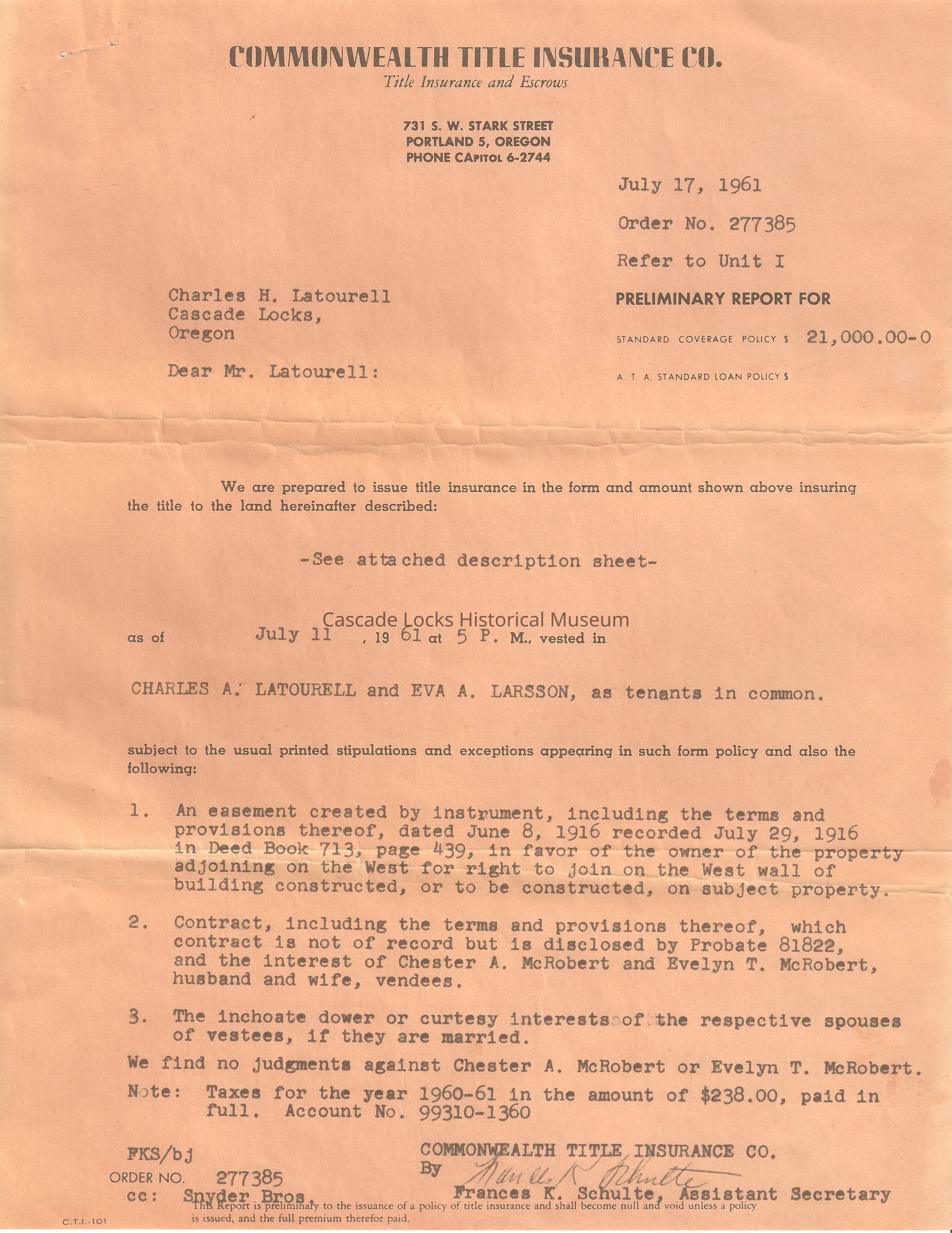
Commonwealth Title Insurance Co. Title Insurance and Escrows 731. S. W. Stark Street. Portland 5, Oregon. Phone Capital 6-2744.
July 17, 1961. Order No. 277385. Refer to unit I Preliminary Report for Standard Coverage Policy $21,000.00-0 A.T.A. Standard Loan Policy $.
Charles H. Latourell, Cascade Locks, Oregon. Dear Mr. Latourell:
We are prepared to issue title insurance in the form and amount shown above insuring the title to the land hereinafter described: (See attached description sheet) as of July 11, 1961at 5 P.M. ., Vested in Charles A. Latourell and Eva A. Larso, as tenants in common. Subject to the usual printed stipulations and exceptions appearing in such form policy and also the following
1) An assessment created by instrument including the terms and provision thereof, dated June 8, 1916, recorded July 29, 1916 in Deed Book 713, Page 439, In favor of the owner of the property adjoining on the west for right to join on the west wall of building constructed, or to be constructed, on subject property.
2) Contract, including the term and provisions thereof, which contract is not of record but is disclosed by probate 81822, and the interest of Chester A. McRobert and Evelyn T. McRobert, Husband and Wife, vendees.
3) The inchoate dower or courtesy interests of the respective spouses of vestees, if they are married.
We find no judgements against Chester A. McRobert or Evelyn T. McRobert. Note: Taxes for the year 1960-61 in the amount of $238.00, paid in full. Account No. 99310-1360.
Commonwealth Title Insurance Co. By Signed Frances K. Schulte, Assistant Sectary.
FKS/bj Order No. 277385 CC: Snyder Bros. CT. T. 101 This report is Preliminary to the insurance of a policy of title insurance and shall become null and void unless a policy is issued and the full premium therefore paid.
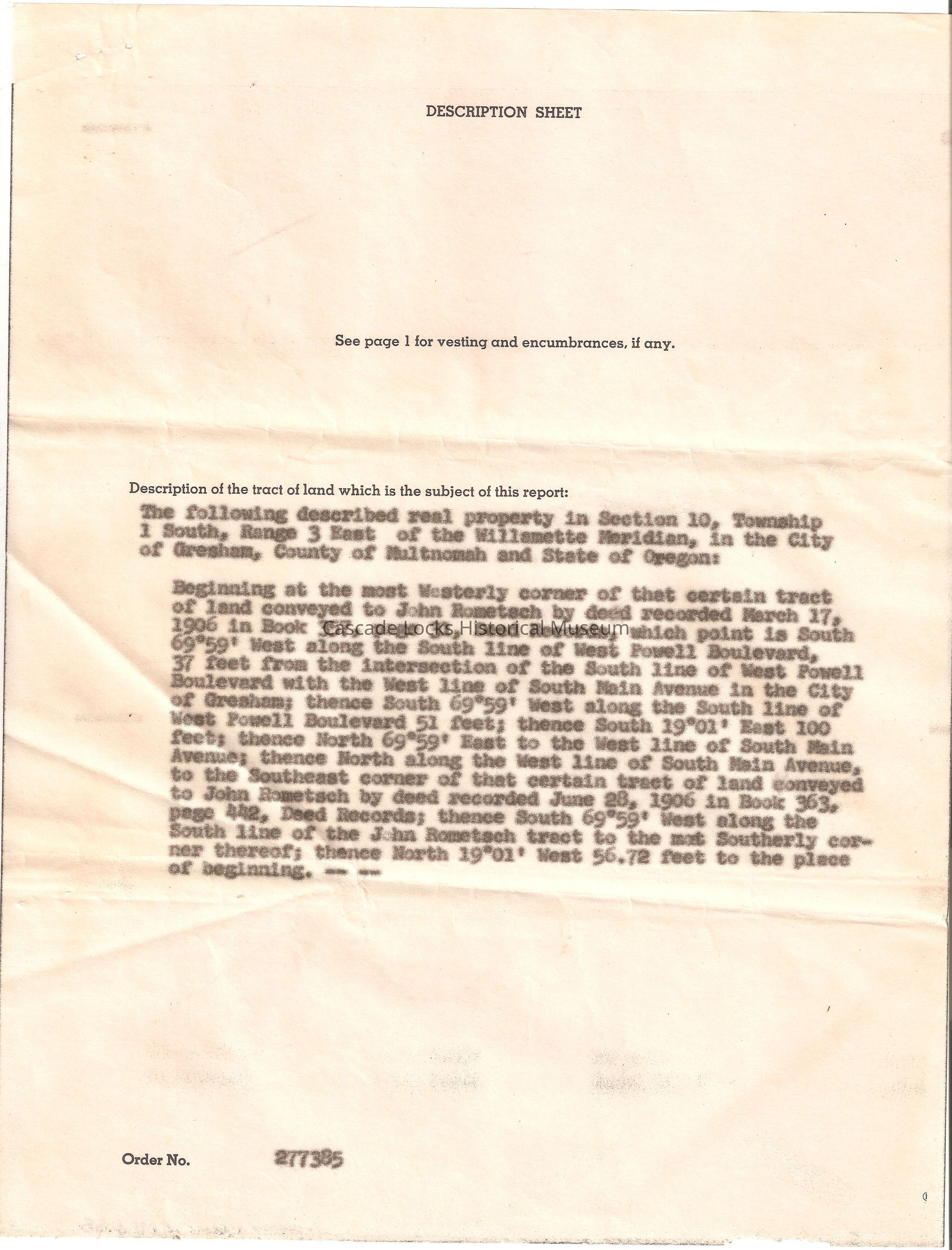
Description Sheet. See page 1 for vesting and encumbrances, if any. Description of the tract of land which is subject of this report.
The following described real property in section 10, Township 1 South, Range 3 East of the Willamette Meridian, in the City of Gresham, County of Multnomah and State of Oregon:
Beginning at the most westerly corner of that certain tract of land conveyed to John Rometsch by deed recorded March 17, 1906 in Book 357, Page 31, Deed Records, which point is South 69' 59' West along the South line of West Powell Boulevard with the west line of South Main avenue in the City of Gresham; thence South 69'59' West along the South line of West Powell Boulevard 51 feet; thence South 19'01' East 100 feet; thence North 69'59' East to the West line of South Main avenue; thence North along the West line of South Main avenue, to the southeast corner of that certain tract of land conveyed to John Rometsch by deed recorded June 28, 1906 in Book 363, Page 442, deed records; thence South 69'59' West along the South line of the John Rometsch tract to the most southernly corner thereof; thence North 19'01' West 56.72 feet to the place of beginning-- -- Order No. 277385.
Document is from a group of documents from the Latourell Estate.Lexicon
Nomenclature 4.0
Nomenclature Primary Object Term
Record, InsuranceNomenclature Sub-Class
Financial RecordsNomenclature Class
Documentary ObjectsNomenclature Category
Category 08: Communication ObjectsDimensions
Height
11 inLength
8-1/2 in