Transcription
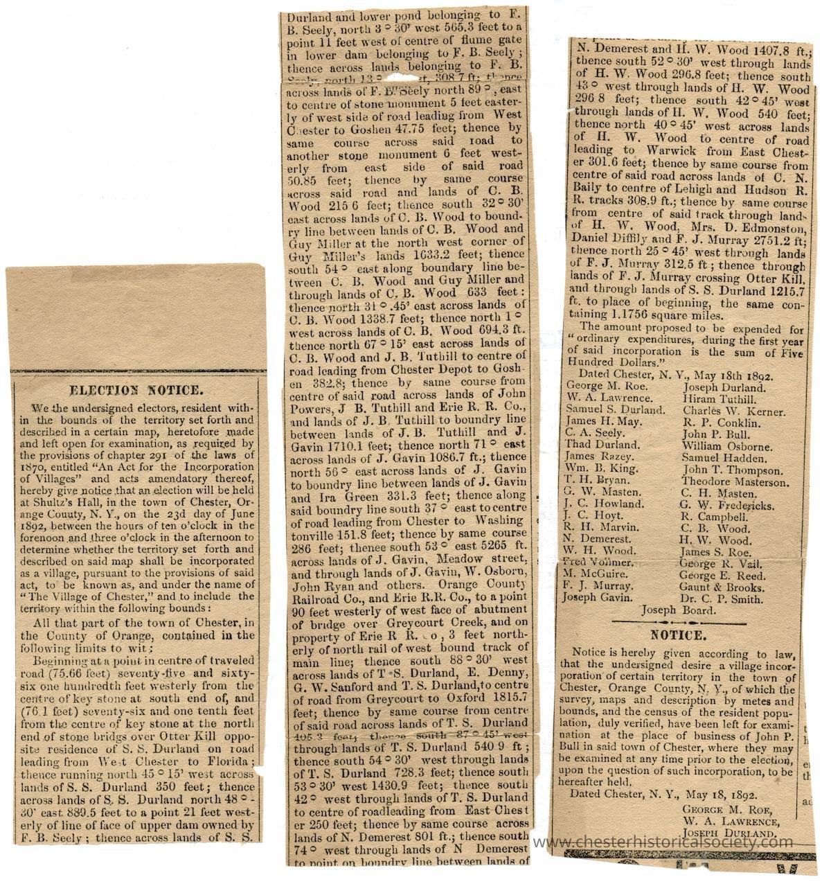
ELECTION NOTICE.
We the undersigned electors, resident within the bounds of the territory set forth and described in a certain map, heretofore made and left open for examination, as required by the provisions of chapter 291 of the laws of 1870, entitled "An Act for the Incorporation of Villages" and acts amendatory thereof, hereby give notice that an election will be held at Shultz's Hall, in the town of Chester, Orange County, N. Y., on the 23d day of June 1892, between the hours of ten o'clock in the forenoon and three o'clock in the afternoon to determine whether the territory set forth and described on said map shall be incorporated as a village, pursuant to the provisions of said act, to be known as, and under the name of "The Village of Chester, and to include the territory within the following bounds:
All that part of the town of Chester, in the County of Orange, contained in the following limits to wit;
Beginning at a point in centre of traveled road (75.66 feet) seventy-five and sixty-six one hundredth feet westerly from the centre of key stone at south end of, and (76.1 feet seventy-six and one tenth feet from the centre of key stone at the north end of stone bridgs over Otter Kill opposite residence of S. S. Durland on road leading from West Chester to Florida; thence running north 45° 15' west across lands of S. S. Durland 350 feet ; thence across lands of S. S. Durland north 48° - 30' east 889.5 feet to a point 21 feet westerly of line of face of upper dam owned by F. B. Seely ; thence across lands of S. S Durland and lower pond belonging to F. B. Seely, north 3 ° 30' west 565.3 feet to a point feet west of centre of flume gate in lower dam belonging to F. B. Seely ; thence across lands belonging to F. B. Seely, north 13 ° [unreadable]t, 308.7 ft; thence across lands of F. B. Sèely north 89 ° east to centre of stone monument 5 feet easterly of west side of road leading from West Chester to Goshen 47.75 feet; thence by same course across said road to another stone monument 6 feet westerly from east side of said road 50.85 feet; thence by same course across said road and lands of C. B. Wood 215[.]6 feet; thence south 32° 30' east across lands of C. B. Wood to boundry line between lands of C. B. Wood and Guy Miller at the north west corner of Guy Miller's lands 1633.2 feet; thence south 54° east along boundary line between C. B. Wood and Guy Miller and through lands of C. B. Wood 633 feet: thence north 31 ° 45' east across lands of C. B. Wood 1338.7 feet; thence north 1 ° west across lands of C. B. Wood 694.3 ft. thence north 67 ° 15' east across lands of C. B. Wood and J. B. Tuthill to centre of road leading from Chester Depot to Goshen 382.8; thence by same course from centre of said road across lands of John Powers, J. B. Tuthill and Erie R. R. Co., and lands of J. B. Tuthill to boundry line between lands of J. B. Tuthill and J. Gavin 1710.1 feet; thence north 71 ° east across lands of J. Gavin 1086.7 ft.; thence north 56 ° east across lands of J. Gavin to boundry line between lands of J. Gavin and Ira Green 331.3 feet; thence along said boundry line south 37 ° east to centre of road leading from Chester to Washingtonville 151.8 feet; thence by same course 286 feet; thence south 53 ° east 5265 ft. across lands of J. Gavin, Meadow street, and through lands of J. Gavin, W. Osborn, John Ryan and others. Orange Counts Railroad Co., and Erie R.R. Co., to a point 90 feet westerly of west face of abutment of bridge over Greycourt Creek, and on property of Erie R R. Co., 3 feet northerly of north rail of west bound track of main line; thence south 88 ° 30' west across lands of T S. Durland, E. Denny, G. W. Sanford and T. S. Durland, to centre of road from Greycourt to Oxford 1815.7 feet; thence by same course from centre of said road across lands of T. S. Durland 405.3 feet, thence south 87 ° 45' west through lands of T. S. Durland 540 9 ft ; thence south 54 ° 30' west through lands of T. S. Durland 728.3 feet; thence south 53 ° 30' west 1430.9 feet; thence south 42 ° west through lands of T. S. Durland to centre of roadleading from East Chester 250 feet; thence by same course across lands of N. Demerest 801 ft.; thence south 74 ° west through lands of N Demerest to point on boundry line between lands of N. Demerest and H. W. Wood 1407.8 ft.; thence south 52 ° 30' west through lands of H. W. Wood 296.8 feet; thence south t8 ° west through lands of H. W. Wood 296 8 feet; thence south 42 ° 45' west through lands of H. W. Wood 540 feet; thence north 40 ° 45' west across lands of H. W. Wood to centre of road leading to Warwick from East Chester 301.6 feet; thence by same course from centre of said road across lands of C. N. Baily to centre of Lehigh and Hudson R. R. tracks 308.9 ft.; thence by same course from centre of said track through lands of H. W. Wood, Mrs. D. Edmonston, Daniel Diffily and F. J. Murray 2751.2 ft; thence north 25 ° 45' west through lands of F. J. Murray 312.5 ft ; thence through lands of F. J. Murray crossing Otter Kill, and through lands of S. S. Durland 1215.7 ft. to place of beginning, the same containing 1.1756 square miles.
The amount proposed to be expended for " ordinary expenditures, during the first year of said incorporation is the sum of Five Hundred Dollars."
Dated Chester, N. Y., May 18th 1892.
George M. Roe. Joseph Durland.
W. A. Lawrence. Hiram Tuthill.
Samuel S. Durland. Charles W. Kerner.
James H. May. R. P. Conklin.
C. A. Seely. John P. Bull.
Thad Durland. William Osborne.
James Razey. Samuel Hadden.
Wm. B. King. John T. Thompson.
T. H. Bryan. Theodore Masterson.
G. W. Masten. C. H. Masten.
T. C. Howland. G. W. Fredericks.
T. C. Hoyt. R. Campbell.
R. H. Marvin. C. B. Wood.
N. Demerest. H. W. Wood.
W. H. Wood. James S. Roe.
Fred Volimer. George R. Vail.
M. McGuire. George E. Reed.
F. J. Murray. Gaunt & Brooks.
Joseph Gavin. Dr. C. P. Smith.
Joseph Board.
–––––—
NOTICE.
Notice is hereby given according to law, that the undersigned desire a village incorporation of certain territory in the town of Chester, Orange County, N. Y., of which the survey, maps and description by metes and bounds, and the census of the resident population, duly verified, have been left for examination at the place of business of John P. Bull in said town of Chester, where they may be examined at any time prior to the election, upon the question of such incorporation, to be hereafter held.
Dated Chester, N. Y., May 18, 1892.
GEORGE M. ROE,
W. A. LAWRENCE,
JOSEPH DURLAND.Transcriber
Clifton Patrick
