Name/Title
Erie Peirmont Branch Track Map CollectionEntry/Object ID
chs-000129Description
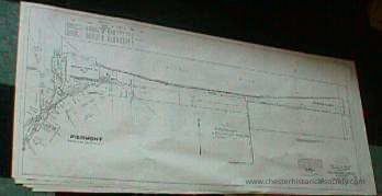
57 x 25” Paper reproductions of the eighteen original linen 1918 Track Maps from Peirmont to Suffern. List owners of acquired properties and some adjacent businesses.Category
Erie, Erie-Lackawana, Conrail
Acquisition
Notes
8/17/2000 Gift from Douglas BarberioMap Details
Maker or Creator
Charles H MoonArea or Region
* Untyped Area or Region
Rockland CountyPublisher
Erie RailRoad CompanyDate Published
Jun 30, 1918Transcription
Map V.2.NY# 1 58+00 to 111+38 Piermont
Map V.2.NY# 2 5+20 to 58+00 Sparkill
Map V.2.NY# 3 5+20 to 59+36
Map V.2.NY# 4 59+36 to 112+16 Orangeburg
Map V.2.NY# 5 112+16 to 164+96 Blauvelt
Map V.2.NY# 6 164+96 to 217+76
Map V.2.NY# 7 217+76 to 270+56
Map V.2.NY# 8 270+56 to 323+36
Map V.2.NY# 9 323+36 to 376+16 Nanuet
Map V.2.NY#10 376+16 to 428+96 Nanuet Jnt
Map V.2.NY#11 428+96 to 481+/6
Map V.2.NY#12 481+76 to 534+56 Spring Valley
Map V.2.NY#13 534+56 to 587+56 Monsey
Map V.2.NY#14 587+36 to 640+16
Map V.2.NY#15 640+16 to 692+96 Tallmans
Map V.2.NY#16 692-96 to 745+76
Map V.2.NY#17 745+76 to 798+56
Map V.2.NY#18 798+56 to 851+36 SuffernDimensions
Height
63.5 cmWidth
144.8 cmCreate Date
October 22, 2024Update Date
November 23, 2024