Name/Title
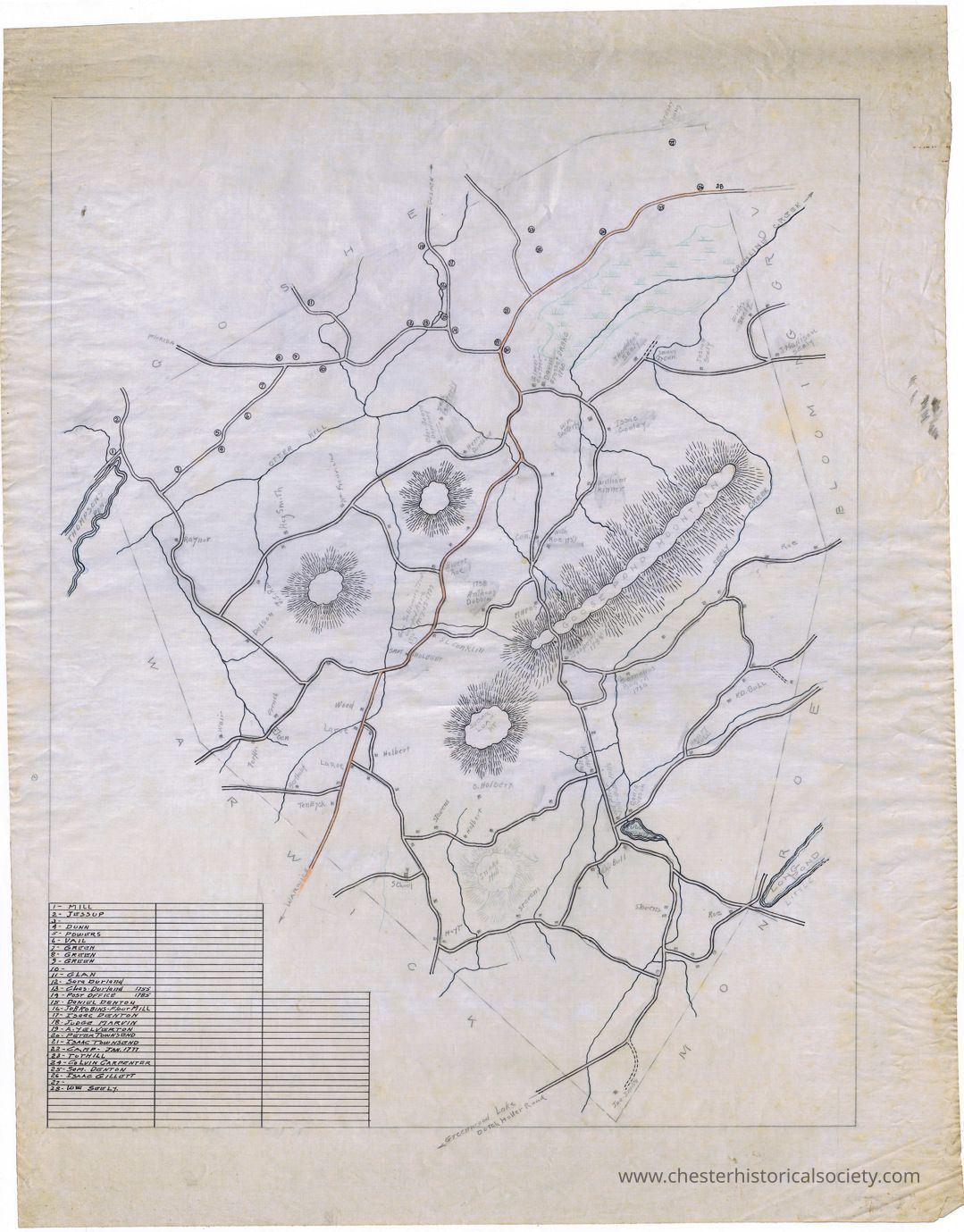
Town of Chester MapEntry/Object ID
chs-013868Description
Town of Chester Map on linen, with early inhabitants, roads, mountains, and geographical features depicted.Collection
W. S. DurlandAcquisition
Accession
W. S. DurlandNotes
2/25/2011 Gift from W. S. DurlandMap Details
Maker or Creator
Frank Durland ?Area or Region
* Untyped Area or Region
Chester (Town) - Orange County - New YorkDate Published
circa 1920Transcription
1 - Mill
2 - Jessup
3 -
4 - Dunn
5 - Powers
6 - Vail
7 - Green
8 - Green
9 - Green
10 -
11 - Glan
12 - Sara Durland
13 - Chas Durland 1755
14 - Post Office 1785
15 - Daniel Denton
16 - Job Robins Flour Mill
17 - Isaac Denton
18 - Judge Marvin
19 - A. Yelverton
20 - Peter Townsend
21 - Isaac Townsend
22 - Camp - Jan. 1777
23 - Tuthill
24 - Colvin Carpenter
25 - Sam. Denton
26 - Isaac Gillett
27 -
28 - Wm. Seely
Ardsey Young
Wicks Seely
J. Madison Seely
Josiah Seely
Seely Cemetery
Thaddeus Seely
David Grosset Drake 1760
Elmer Cooper
Henry Durland
Seth Sattery
Chas. Board Durland
Wm. Fredricks
Hez. Smith
J. J. Roe
Raynor
Dolson
French
Cemetery
Turfler
Weir
Bertholf
Ten Eyck
Laroe
Laroe
Holbert
Wood
Sam Holdbert
Gen. Sullivan’s Troops Camped Here May 19, 1779
S. L. Conklin
Rivert Roe
1738 Anthony Dobbin
Cemetery
Nath Roe 1739
William Kinner
Isaac Cooly
Wm. Satterly
Mapes
Stephen Cooper 1788
Cornelius Board 1730
Roe
K. D. Bull
Henry Bull
David Gibson
Old Flour Mill - Bull’s Mill
Pete Board
O. Holbert
Holbert
Stevens
School
Hoylt
Stevens
Rich. Bull
Stevens
Jno. Smith
RoeDimensions
Height
58.7 cmWidth
44.8 cmCreate Date
October 22, 2024Update Date
December 29, 2024