Map of Orange and Rockland Cos., New York
Map of Orange and Rockland Cos., New York
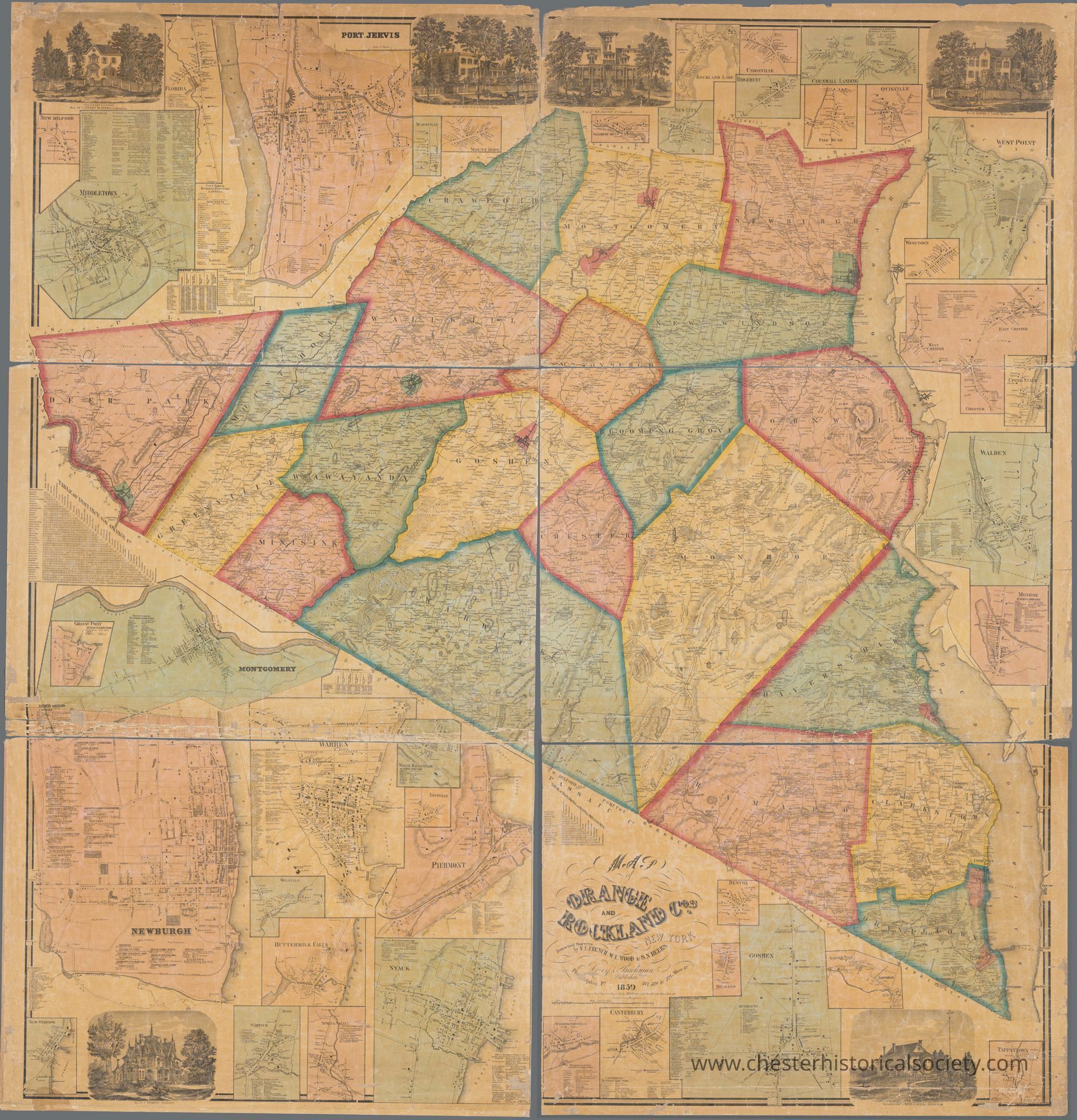
The image displays the 1859 Corey & Bachman map of Orange and Rockland counties, showing various towns and geographical features.
Name/Title
Map of Orange and Rockland Cos., New YorkEntry/Object ID
chs-016328Description
Original held by: Lionel Pincus and Princess Firyal Map Division, The New York Public Library. "Map of Orange and Rockland Cos., New York" The New York Public Library Digital Collections. TITLE Map of Orange and Rockland Cos., New York Additional title: Map of Orange and Rockland counties New York NAMES French, Frank F. (Surveyor) (Surveyor) Wood, W. E. (Surveyor) Beers, S. N. (Surveyor) Corey and Bachman (Publisher) COLLECTION Maps of New York City and State Counties DATES / ORIGIN Date Issued: 1859 Place: Philadelphia, Pa. Publisher: Corey & Bachman LIBRARY LOCATIONS Lionel Pincus and Princess Firyal Map Division Shelf locator: Map Div. 16-6014 TOPICS Real property -- New York (State) -- Rockland County Landowners -- New York (State) -- Rockland County Real property -- New York (State) -- Orange County Landowners -- New York (State) -- Orange County Rockland County (N.Y.) Rockland County (N.Y.) -- Administrative and political divisions Orange County (N.Y.) Orange County (N.Y.) -- Administrative and political divisions GENRES Maps Cadastral maps NOTES Statement of responsibility: by F.F. French, W.E. Wood and S.N. Beers. Content: Shows cities and towns, post offices, roads, railroads, land tracts (some numbered, some with owner's name) and major natural features. Content: Relief shown by hachures. Content: Includes insets of towns, some with business directories: New Milford -- Middletown -- Florida -- Port Jervis -- Searsville -- Mount Hope -- Grassy Point -- Montgomery -- Newburgh -- Warren -- North Haverstraw -- Edenville -- Piermont -- Bellvale -- Buttermilk Falls -- New Windsor -- Warwick -- Spring Valley -- Nyack -- Denton -- Sugar Loaf -- Washingtonville -- Canterbury-- Goshen -- Garner Ville -- Sampsondale -- Tappantown -- Monroe -- Walden -- Chester -- Upper Nyack -- Westtown -- West Point -- Otisville -- Pine Bush -- Cornwall Landing -- Unionville -- Ridgebury -- Rockland Lake -- New City -- Salisbury Mills. Content: Also Includes table of distances, statistical tables, and vignettes of prominent homes. Funding: Mapping the Nation (NEH grant, 2015-2018) PHYSICAL DESCRIPTION Extent: 1 map : hand colored ; 159 x 154 cm, on sheet 166 x 160 cm TYPE OF RESOURCE Cartographic IDENTIFIERS RLIN/OCLC: 41169253 NYPL catalog ID (B-number): b20645841 Other local Identifier: US167.5.01 Universal Unique Identifier (UUID): 315f5530-04c2-0134-8daa-00505686a51cCollection
The New York Public Library CollectionCategory
Orange County
Other Locales