A General Contraction Map 2 Miles to an Inch. No 37 _ by R.E. ; by Robert Erskine F.R.S. Geogr. A. U.S. and Assistants
A General Contraction Map 2 Miles to an Inch. No 37 _ by R.E. ; by Robert Erskine F.R.S. Geogr. A. U.S. and Assistants
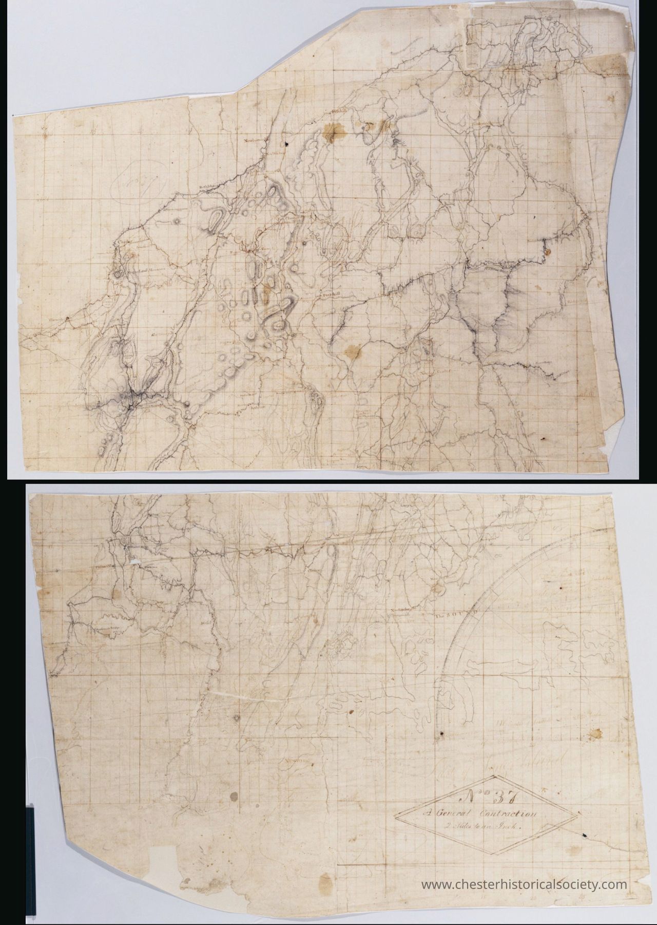
The image displays two adjacent sections of an old, weathered map with faint grid lines and a series of intricate ink-drawn pathways and terrains, showcasing detailed topographical features such as hills, valleys, and rivers from New York City to Fishlill. The map is aged and shows discolorations, folds, and tears, adding character and a historical aesthetic. The bottom section includes a title or label within a diamond-shaped frame, enhancing its archival and cartographic value. The entire piece evokes a sense of exploration and the meticulous artistry involved in
Name/Title
A General Contraction Map 2 Miles to an Inch. No 37 _ by R.E. ; by Robert Erskine F.R.S. Geogr. A. U.S. and AssistantsEntry/Object ID
chs-019510Secondary Title
This General Contraction Map 2 Miles to an Inch. No 37 _ by R.E. ; by Robert Erskine F.R.S. Geogr. A. U.S. and Assistants displays two adjacent sections of an old, weathered map with faint grid lines and a series of intricate ink-drawn pathways and terrains, showcasing detailed topographical features such as hills, valleys, and rivers from New York City to Fishlill.Description
Descriptive Metadata Hide Details Creator / Contributor Erskine, Robert, 1735-1780 De Witt, Simeon, 1756-1834 De Witt, Richard Varrick United States. Continental Army. Surveying Dept. Title A General Contraction 2 Miles to an Inch. No 37 / by R.E. ; by Robert Erskine F.R.S. Geogr. A. U.S. and Assistants, top General contraction two miles to an inch General Contraction 2 Miles to an inch. 37 Alternative Title General contraction two miles to an inch General Contraction 2 Miles to an inch. 37 Date 1778 Physical Description 1 map on several assembled sheets : ms. ; 102 x 70 cm., irregularly shaped Series Rough draughts of surveys, begun A.D. 1778 ; 037 Description Military topographic map. Covers the lower Hudson River Valley in New York, New Jersey and Connecticut, from Warwick (N.Y.) and Pompton Plains (N.J.) to New Milford and Danbury (Conn.), and from Newburgh (N.Y.) to Staten Island (N.Y.). Shows roads, buildings and owners’ names, also landforms and streams. Shows relief by hachures. Title proper from recto is the work of a later editor--Simeon DeWitt or his assign--subsequent to 1820. Index title, both statements of responsibility, date, series title and series numbering by Erskine, but on separate index sheet filed at head of series. Pen-and-ink, pencil on laid paper (one principal sheet has small pieces of four others pasted to its upper right). Watermark: "Pz". Faded, stained, foxed, creased, frayed, and badly faded. Cut into two pieces. Mounted on cloth, bound and cropped, disbound and silked by subsequent owners. Cleaned after removal of backings 1999; some fill remains. Sheathed in mylar. May be imperfect; Erskine’s index states "3 pieces & [1] D[itt]o". Includes texts (severely faded). In pencil on recto: "No 37". In ink on verso: "No 37", "No 37 1st". Scale Scale [1:126,700] 2 mi. to an in. Coordinates (W 74⁰18ʹ--W73⁰23ʹ/N 41⁰40ʹ--N40⁰35ʹ) Identifier Maps -- M30 M004757 n000049m Subject Buildings--New York (State)--Maps Landforms--New York (State)--Maps Landowners--New York (State)--Maps Roads--New York (State)--Maps Rivers--New York (State)--Maps Buildings--New Jersey--Maps Landforms--New Jersey--Maps Landowners--New Jersey--Maps Roads--New Jersey--Maps Rivers--New Jersey--Maps Buildings--Connecticut--Maps Landforms--Connecticut--Maps Landowners--Connecticut--Maps Rivers--Connecticut--Maps Roads--Connecticut--Maps Subject geographic name Hudson River Valley (N.Y. and N.J.)--History--18th century--Campaigns--Maps, Manuscript Fairfield County (Conn.)--History--Revolution, 1775-1783--Campaigns--Maps, Manuscript Litchfield County (Conn.)--History--18th century--Campaigns--Maps, Manuscript Dutchess County (N.Y.)--History--18th century--Campaigns--Maps, Manuscript Putnam County (N.Y.)--History--18th century--Campaigns--Maps, Manuscript Westchester County (N.Y.)--History--18th century--Campaigns--Maps, Manuscript Orange County (N.Y.)--History--18th century--Campaigns--Maps, Manuscript Rockland County (N.Y.)--History--18th century--Campaigns--Maps, Manuscript Bergen County (N.J.)--History--Revolution, 1775-1783--Campaigns--Maps, Manuscript Passaic County (N.J.)--History--18th century--Campaigns--Maps, Manuscript Morris County (N.J.)--History--18th century--Campaigns--Maps, Manuscript Essex County (N.J.)--History--18th century--Campaigns--Maps, Manuscript Union County (N.J.)--History--18th century--Campaigns--Maps, Manuscript Material type or medium of original manuscript maps Rights This digital image may be used for educational or scholarly purposes without restriction. Commercial and other uses of the item are prohibited without prior written permission from the New-York Historical Society. For more information, please visit the New-York Historical Society's Rights and Reproductions Department web page at http://www.nyhistory.org/about/rights-reproductionsCollection
New-York Historical SocietyCategory
War, Revolutionary 1775-1783