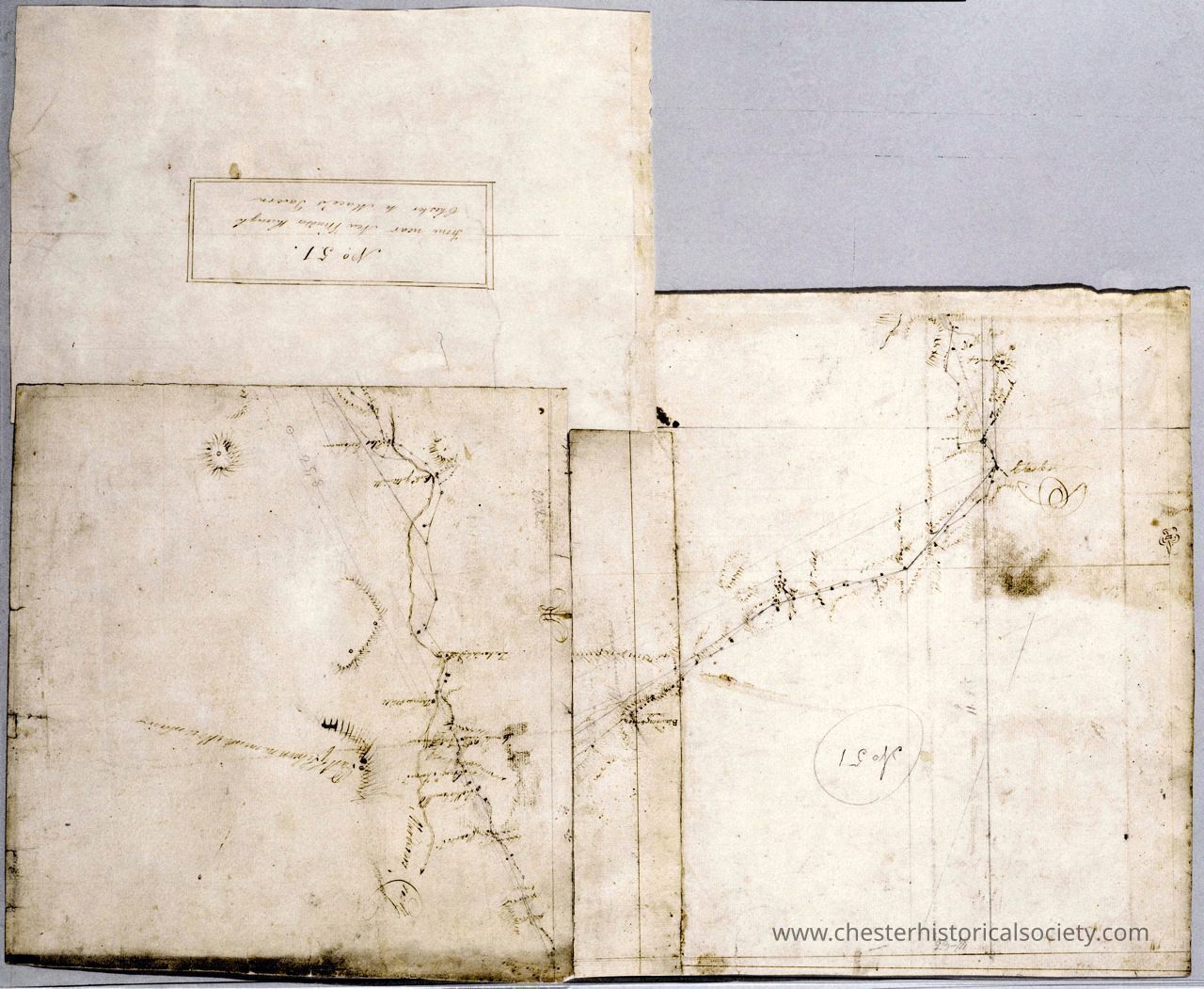
Map from near New Windsor through Chester to Mace’s Tavern. No. 51 _ by Robert Erskine F.R.S. Geogr. A. U.S. and Assistants.
Map from near New Windsor through Chester to Mace’s Tavern. No. 51 _ by Robert Erskine F.R.S. Geogr. A. U.S. and Assistants.
The image depicts an old, intricately sketched manuscript featuring a map or a diagram with hand-drawn lines, circles, and various annotations scattered across the aged, slightly stained paper, interspersed with delicate, legible script and some areas highlighting darker smudges, enhancing the historic and antique appearance of the document.
Name/Title
Map from near New Windsor through Chester to Mace’s Tavern. No. 51 _ by Robert Erskine F.R.S. Geogr. A. U.S. and Assistants.Entry/Object ID
chs-019511Description
In Collection(s) • Robert Erskine-Simeon DeWitt maps, 1778-1783 Descriptive Metadata Hide Details Creator / Contributor Erskine, Robert, 1735-1780 De Witt, Simeon, 1756-1834 De Witt, Richard Varrick United States. Continental Army. Surveying Dept. Title From near New Windsor through Chester to Mace’s Tavern. No. 51 / by Robert Erskine F.R.S. Geogr. A. U.S. and Assistants. Road near Newwindsor through Chester to Maces. 51 Near Newwindsor through Chester to [Maces]. 51 From New Windsor thorugh Chester to Mace’s Tavern. N 51 Near New windsor through Chester to Maces Alternative Title Road near Newwindsor through Chester to Maces. 51 Near Newwindsor through Chester to [Maces]. 51 From New Windsor thorugh Chester to Mace’s Tavern. N 51 Near New windsor through Chester to Maces Date 1778 Physical Description 1 map on several assembled sheets : ms. ; 40 x 72 cm., on sheet 58 x 70 cm., irregularly shaped Series Rough draughts of surveys, begun A.D. 1778 ; 051 Description Imperfect: separate piece of original (laid paper) lost from lower left corner; note evidence of pasting. In ink on verso: "No. 51." "Rough Draughts". In pencil on recto: "No 51". In pencil on verso: "Fort Washington." Military topographic map. Covers the towns of Chester, Blooming Grove, Cornwall and New Windsor in Orange County, New York. Shows roads running through Vailsgate, Meadowbrook, Salisbury Mills, Washingtonville, Blooming Grove, Craigsville, Chester and East Chester. Also shows buildings and owners’ names, landforms and streams. No watermarks. Pen-and-ink, later pencil on two pieces laid paper. The larger part of the upper right piece is improperly assembled to the others and needs to be rotated ninety degrees so that the compass rosette now at left sits at top; note chainlines as well as geography. Wove finish on third piece. Shows relief by hachures. Stained, foxed, creased, cut and badly abraded. Mounted on cloth, bound and cropped, disbound and silked by subsequent owners. Cleaned after removal of backings 1999; some fill remains. Sheathed in mylar. Partly lined with China paper. Title and number also on verso. Title proper from recto is the work of a later editor--Simeon DeWitt or his assign--subsequent to 1820. Title from verso is in Erskine’s hand and may be cited as such. Index title, statement of responsibility, date, series title and series numbering also by Erskine, but on separate index sheet filed at head of series. References: Heusser, Albert H. George Washington’s Map Maker, p. 249-256. Scale Scale not given. Coordinates (W 74⁰17ʹ--W74⁰03ʹ/N 41⁰28ʹ--N41⁰21ʹ) Identifier Maps -- M30 M004430 n000068m Subject Buildings--New York (State)--Maps Landforms--New York (State)--Maps Landowners--New York (State)--Maps Rivers--New York (State)--Maps Roads--New York (State)--Maps Subject geographic name Hudson River Valley (N.Y. and N.J.)--History--18th century--Campaigns--Maps, Manuscript Orange County (N.Y.)--History--18th century--Campaigns--Maps, Manuscript Material type or medium of original manuscript maps Rights This digital image may be used for educational or scholarly purposes without restriction. Commercial and other uses of the item are prohibited without prior written permission from the New-York Historical Society. For more information, please visit the New-York Historical Society's Rights and Reproductions Department web page at http://www.nyhistory.org/about/rights-reproductionsCollection
New-York Historical SocietyCategory
War, Revolutionary 1775-1783