Name/Title
Erie Peirmont Branch Track Map CollectionEntry/Object ID
chs-000129Tags
MapsDescription
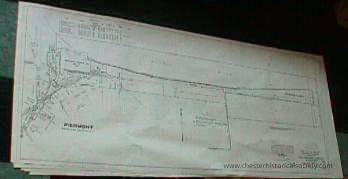
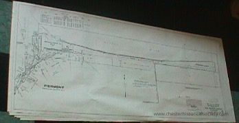
57 x 25” Paper reproductions of the eighteen original linen 1918 Track Maps from Peirmont to Suffern. List owners of acquired properties and some adjacent businesses.Category
Erie, Erie-Lackawana, Conrail
Acquisition
Notes
8/17/2000 Gift from Douglas BarberioMap Details
Maker or Creator
Charles H MoonArea or Region
* Untyped Area or Region
Rockland CountyPublisher
Erie RailRoad CompanyDate Published
Jun 30, 1918Transcription
Map V.2.NY# 1 58+00 to 111+38 Piermont
Map V.2.NY# 2 5+20 to 58+00 Sparkill
Map V.2.NY# 3 5+20 to 59+36
Map V.2.NY# 4 59+36 to 112+16 Orangeburg
Map V.2.NY# 5 112+16 to 164+96 Blauvelt
Map V.2.NY# 6 164+96 to 217+76
Map V.2.NY# 7 217+76 to 270+56
Map V.2.NY# 8 270+56 to 323+36
Map V.2.NY# 9 323+36 to 376+16 Nanuet
Map V.2.NY#10 376+16 to 428+96 Nanuet Jnt
Map V.2.NY#11 428+96 to 481+/6
Map V.2.NY#12 481+76 to 534+56 Spring Valley
Map V.2.NY#13 534+56 to 587+56 Monsey
Map V.2.NY#14 587+36 to 640+16
Map V.2.NY#15 640+16 to 692+96 Tallmans
Map V.2.NY#16 692-96 to 745+76
Map V.2.NY#17 745+76 to 798+56
Map V.2.NY#18 798+56 to 851+36 SuffernDimensions
Height
63.5 cmWidth
144.8 cmGeneral Notes
Note
Map
Paper reproductions of the eighteen original linen 1918 Track Maps from Peirmont to Suffern. List owners of acquired properties and some adjacent businesses.
8/17/2000Create Date
October 22, 2024Update Date
February 16, 2026