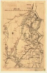
[Map of Orange and Rockland counties area of New York] Copied from surveys laid down by R. Erskine, F.R.S. 1778, 1779.
![[Map of Orange and Rockland counties area of New York] Copied from surveys laid down by R. Erskine, F.R.S. 1778, 1779.: An old, detailed map copied from surveys laid down by R. Erskine, F.R.S. 1778, 1779 showing a region that includes parts of New York and New Jersey, with various towns like Newborough, New Windsor, Blooming Grove, and Chester marked. It features rivers, labeled as the Hudson River and various other smaller bodies of water, including Cedar Pond and Beaver Pond. The map also illustrates different topographical features like forests, hills, and valleys.](https://d8e7jbdw4fu0e.cloudfront.net/13108/966dc1d0-c56c-11ef-831d-e5b30743e039-vbpRlmm.lg@2x.jpg)
[Map of Orange and Rockland counties area of New York] Copied from surveys laid down by R. Erskine, F.R.S. 1778, 1779.
An old, detailed map copied from surveys laid down by R. Erskine, F.R.S. 1778, 1779 showing a region that includes parts of New York and New Jersey, with various towns like Newborough, New Windsor, Blooming Grove, and Chester marked. It features rivers, labeled as the Hudson River and various other smaller bodies of water, including Cedar Pond and Beaver Pond. The map also illustrates different topographical features like forests, hills, and valleys.
Name/Title
[Map of Orange and Rockland counties area of New York] Copied from surveys laid down by R. Erskine, F.R.S. 1778, 1779.Entry/Object ID
chs-011245Tags
MapsDescription
An old, detailed map copied from surveys laid down by R. Erskine, F.R.S. 1778, 1779 showing a region that includes parts of New York and New Jersey, with various towns like Newborough, New Windsor, Blooming Grove, and Chester marked. It features rivers, labeled as the Hudson River and various other smaller bodies of water, including Cedar Pond and Beaver Pond. The map also illustrates different topographical features like forests, hills, and valleys. The original is held by the Library of Congress Geography and Map Division Washington, D.C. 20540-4650 USACategory
Maps