Name/Title
Provinces of New York and New JerseyEntry/Object ID
chs-012038Description
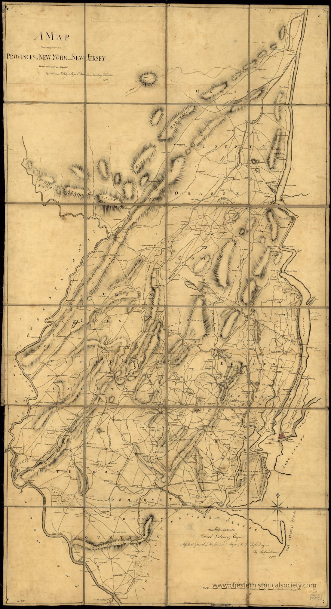
A map containing part of the Provinces of New York and New Jersey, drawn from surveys compiled by Thomas Millidge, major 1st Battalion, New Jersey Volunteers, 1780.
Shows the area between the Hudson and Delaware Rivers, from Kingston, N.Y. to Trenton, including names of some property owners. Drawn in 1781 by Andrew Skinner.
The original is held by the Library of Congress Geography and Map Division Washington, D.C.Acquisition
Notes
2/14/2009 Download by Clifton PatrickMap Details
Maker or Creator
Andrew SkinnerDate Published
1781General Notes
Note Type
Cataloging NoteNote
Title
A map containing part of the Provinces of New York and New Jersey,
Names
Skinner, Andrew (Geographer)
Millidge, Thomas.
De Lancey, Oliver, 1752-1822.
Created / Published
[1781]
Headings
- New York (State)--Maps, Manuscript--Early works to 1800
- New Jersey--Maps, Manuscript--Early works to 1800
- Real property--New York (State)--Maps--Early works to 1800
- Real property--New Jersey--Maps--Early works to 1800
- United States--New York (State)
- United States--New Jersey
Notes
- Scale ca. 1:126,000.
- Manuscript, pen-and-ink and watercolor.
- Relief shown by shading.
- Shows area between the Hudson and Delaware Rivers, from Kingston, N.Y. to Trenton, including names of some property owners.
- LC Maps of North America, 1750-1789, 1053
- Vault
- AACR2: 100; 651/1; 651/2; 650/3; 650/4; 700/1
Medium
col. map 167 x 90 cm.
Call Number/Physical Location
G3800 1781 .S5
Repository
Library of Congress Geography and Map Division Washington, D.C. 20540-4650 USA dcu
Digital Id
http://hdl.loc.gov/loc.gmd/g3800.ar105300
Library of Congress Control Number
gm71005417
Online Format
image
LCCN Permalink
https://lccn.loc.gov/gm71005417
Additional Metadata Formats
MARCXML Record
MODS Record
Dublin Core Record
IIIF Presentation Manifest
Manifest (JSON/LD)Create Date
October 22, 2024Update Date
February 16, 2026