Name/Title
Plan of Several Lots of Land and the Buildings Thereon ... Belonging to Capt. John BonnellEntry/Object ID
ATLANTIC.004.3Description
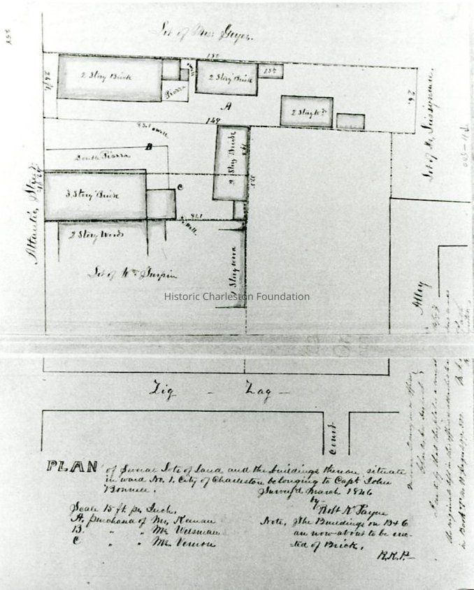
Photographic reprint of a plat showing the "lands belonging to Capt. John Bonnell." Features lots on Atlantic Street, from 4-10 Atlantic, to the west from the corner of Zig Zag Alley. Surveyed March 1846 by Robert K. Payne.Collection
Historic Charleston Foundation Property RecordsAcquisition
Accession
ATLANTIC.004.Source or Donor
4 Atlantic StreetAcquisition Method
Collected by StaffLexicon
Nomenclature 4.0
Nomenclature Tertiary Object Term
PlatNomenclature Secondary Object Term
MapNomenclature Primary Object Term
CartographNomenclature Sub-Class
Graphic DocumentsNomenclature Class
Documentary ObjectsNomenclature Category
Category 08: Communication ObjectsLOC Thesaurus for Graphic Materials
PlatsSearch Terms
Atlantic Street, Zig Zag Alley, Streets--South Carolina--CharlestonDimensions
Height
5 inWidth
6-1/2 inDimension Notes
Printed on 8x10 paperLocation
Location
Cabinet
Photo File CabinetsRoom
Margaretta P. Childs ArchivesBuilding
Missroon HouseCategory
PermanentDate
February 7, 2023Relationships
Related Entries
Notes
ATLANTIC.004.1, ATLANTIC.004.2Provenance
Notes
Likely a plat from the Charleston Register of Mesne Conveyance; item number not indicated.Copyright
Copyright Details
Public domain.General Notes
Note
Notes: Photographed by William Struhs.Created By
admin@catalogit.appCreate Date
March 15, 2017Updated By
admin@catalogit.appUpdate Date
February 17, 2023