Name/Title
Anson Street (General)Entry/Object ID
ANSON.GEN.001Scope and Content
One of the boundaries of Ansonborough, the city's first borough or suburb. Named for Captain (later Admiral and Baron) George Anson.
Anson Street, laid out in 1745-46 as part of the suburb of Ansonborough, originally extended between George and Centurion (now part of Society) streets. Scarborough Street, named for one of Lord Anson's ships, ran from George to Boundary (Calhoun) Street. To the south, Quince (named for Parker Quince, husband of Susannah Rhett) ran from Centurion to Pinckney, through Rhettsbury, and Charles Street (named for Charles Pinckney) ran from Pinckney to Market, through Colleton Square. By city ordinance, in 1805, Charles, Quince and Scarborough streets became part of Anson Street (Charleston Streets website).
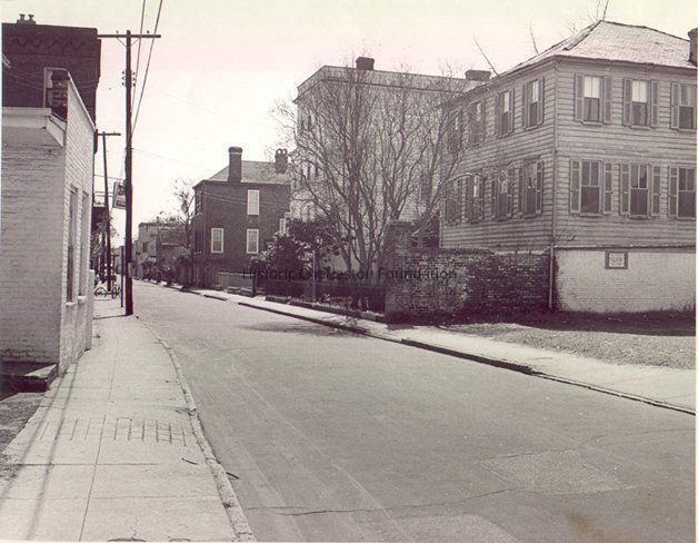
File contains general information about Anson Street addresses; photocopies of photographs of the southeast corner of Anson Street; Evening Post newspaper article, 12/6/1965, "Foundation Will Save Two Houses" re: houses at 114 Anson Street and 15 Wall Street being moved to the southeast corner of at Anson and Lauren Streets.Collection
Historic Charleston Foundation Property RecordsAcquisition
Accession
ANSON.GEN.Source or Donor
Anson Street (General)Acquisition Method
Collected by StaffLexicon
Search Terms
Anson Street, Ansonborough, Relocated buildings, Streets--South Carolina--CharlestonArchive Details
Archive Size/Extent
1 File FolderArchive Notes
Finding Aids: Index to Property Files
Level of Description: FolderLocation
Location
Shelf
Property File ShelvesRoom
Margaretta P. Childs ArchivesBuilding
Missroon HouseCategory
PermanentDate
February 7, 2023Notes
PF Box 8Relationships
Related Entries
Notes
ANSON.082.001, ANSON.082.002, ANSON.082.003A-B, ANSON.082.004, ANSON.082.005A-B, ANSON.082.006A-B, ANSON.082.007a-b, ANSON.082.008, ANSON.082.010a-b, ANSON.082.011
Related Units of Description: See also "Ansonborough" document box, Preservation Topics shelves.Related Publications
Notes
Buildings of Charleston (see Abstract), p. 411.Interpretative Labels
Label Type
Online CatalogLabel
One of the boundaries of Ansonborough, the city's first borough or suburb. Named for Captain (later Admiral and Baron) George Anson.
Anson Street, laid out in 1745-46 as part of the suburb of Ansonborough, originally extended between George and Centurion (now part of Society) streets. Scarborough Street, named for one of Lord Anson's ships, ran from George to Boundary (Calhoun) Street. To the south, Quince (named for Parker Quince, husband of Susannah Rhett) ran from Centurion to Pinckney, through Rhettsbury, and Charles Street (named for Charles Pinckney) ran from Pinckney to Market, through Colleton Square. By city ordinance, in 1805, Charles, Quince and Scarborough streets became part of Anson Street (Charleston Streets website).
File contains general information about Anson Street addresses; photocopies of photographs of the southeast corner of Anson Street; Evening Post newspaper article, 12/6/1965, "Foundation Will Save Two Houses" re: houses at 114 Anson Street and 15 Wall Street being moved to the southeast corner of at Anson and Lauren Streets.Created By
admin@catalogit.appCreate Date
December 22, 2004Updated By
sferguson@historiccharleston.orgUpdate Date
August 8, 2023