Name/Title
Early 20th Century Charleston ScenesEntry/Object ID
2012.003.08a-cTags
Content warningDescription
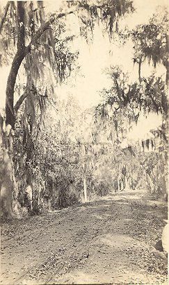
Three photographs, early 20th century, each with handwritten descriptions on back:
a: Tree-lined dirt road.
b: View of tall trees with a boy at the top of one.
c: Landscape with trees. Buildings barely visible in background.Collection
HCF Image CollectionAcquisition
Accession
2012.003.Source or Donor
New Photos Catalog Records (2012)Acquisition Method
Found in CollectionInscription/Signature/Marks
Type
InscriptionLocation
back of photograph (a)Transcription
Summerville Road.Notes
Today, Highway 61 (Ashley River Road).Type
InscriptionLocation
back of photograph (b)Transcription
Negro boy gathering mistletoe.Type
InscriptionLocation
back of photograph (c)Transcription
Indian Hill, where the first white people landed in Charleston by fighting and whipping the Indians.Lexicon
Nomenclature 4.0
Nomenclature Primary Object Term
PhotographNomenclature Sub-Class
Graphic DocumentsNomenclature Class
Documentary ObjectsNomenclature Category
Category 08: Communication ObjectsLOC Thesaurus for Graphic Materials
Streets, Trees, Landscape photographs, MistletoeSearch Terms
Rural roads, Ashley River Region (S.C.)Location
Location
Container
PhotoBox 15Shelf
AV MaterialsRoom
Margaretta P. Childs ArchivesBuilding
Missroon HouseCategory
PermanentDate
February 7, 2023Provenance
Notes
Found in a box of miscellaneous unidentified photographs.Research Notes
Notes
Excerpt, Post & Courier, Feb. 27, 2012, by Bo Petersen, "Indian Hill's Truth":
The hill is a sand bluff along the Ashley River on The Citadel military college campus, the rise where the water tower stands today. It climbs some 15 feet from the marshes, making it the highest natural ground on the Charleston peninsula. ... The rise has been called Indian Hill for as long as anyone remembers, maybe because its camel-hump shape resembles a native ceremonial mound. The "Indian" legend of its origin was widely accepted for generations, until archaeologists in the 1970s excavated and disproved it. They did find a brick wall, a clay pipe, a pewter spoon, a shutter pin and -- incongruously -- native American pottery fragments. They concluded the hill was the site or very near the site of the colonial Gibbs plantation house, a trading family that likely did business with native tribes. ... Almost directly across the Ashley from the hill is Charles Towne Landing, the original city site and the spot where a ferry ran to the Gibbs Plantation and the Lowndes Grove Plantation nearby. (http://www.postandcourier.com/article/20120227/PC1602/302279928)Created By
admin@catalogit.appCreate Date
May 3, 2012Updated By
sferguson@historiccharleston.orgUpdate Date
September 1, 2023