Name/Title
Beaufain Street (General)Entry/Object ID
BEAUFAIN.GEN.001Scope and Content
Beaufain Street was platted as part of Harleston Village in 1770; it followed the north line of the original Grand Modell of Charles Town and of the Mazyck Lands, which was also the south boundary of the Glebe Lands and the Harleston lands. The street was named for Hector Berenger de Beaufain, a French Huguenot who came to South Carolina about 1735 and lived here until his death in 1766. He was a prominent and "well-beloved" citizen, a member of the St. Andrews Society and other organizations here and abroad. He was one of the founders of the Charleston Library Society, a member of his Majesty's Council, and for 24 years was Collector of Customs. He was buried in St. Philip's churchyard and a monument given by his fellow citizens was placed in the church. The monument was destroyed when the church burned in 1835. Beaufain's monument bore witness to his "unshaken integrity" as customs collector. McCrady states that South Carolina, enjoying a lucrative trade with London and special privilege under the trade laws, which allowed rice to be shipped directly to Spain, Portugal and the Mediterranean, was not annoyed with the Navagation Acts, as were the northern colonies, where smuggling became a way of life. Therefore Charlestonians had no reason for hostility to the Royal customs officials until the adoption of the Stamp Act, 1764. (Source: Charleston Streets, website)
File contains copies from the Census of Charleston (no date indicated) with the names of owners and occupants on Beaufain Street, also indicating whether the dwelling is brick or wood; also contains copy of the 1888 Sanborn Map for a section of Beaufain Street; illustration of the business at 30-36 Beaufain Street, F.J. Lilienthal & Son, Hay, Grain, Grist & Grocer, ca. 1899; copy of photo from "Resources & Attractions of Charleston" (ca. 1898) of west end of Beaufain Street (poor quality but original book is at Charleston Library Society); history of Beaufain Street (a/k/a Hind Street) from Charleston Streets by E. Burton Milby; Sanborn Maps and newspaper articles about the house at 52 Beaufain Street which was demolished for the construction of Memminger High School that later became Memminger Auditorium.Collection
Historic Charleston Foundation Property RecordsAcquisition
Accession
BEAUFAIN.GEN.Source or Donor
Beaufain Street (General)Acquisition Method
Collected by StaffLexicon
Search Terms
Beaufain Street, Harleston Village, Streets--South Carolina--CharlestonArchive Details
Archive Size/Extent
1 File FolderArchive Notes
Finding Aids: Index to Property Files.
Level of Description: FolderLocation
Location
Shelf
Property File ShelvesRoom
Margaretta P. Childs ArchivesBuilding
Missroon HouseCategory
PermanentDate
February 7, 2023Location
Container
PF Box 7Shelf
Prop File Shelves, Property File ShelvesRoom
Margaretta P. Childs ArchivesBuilding
Missroon HouseCategory
PermanentGeneral Notes
Note
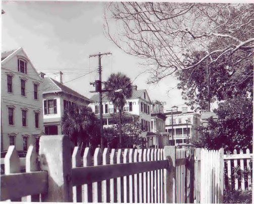
Notes: Image #2 presumed to be the Beaufain Street side, southwest corner of Beaufain and Archdale Streets (per photo caption in USGS photo library).
Image #3: postcard copied from eBay website.Created By
admin@catalogit.appCreate Date
August 31, 2005Updated By
admin@catalogit.appUpdate Date
February 17, 2023