Name/Title
Street Map of Old CharlestonEntry/Object ID
2004.019.2Scope and Content
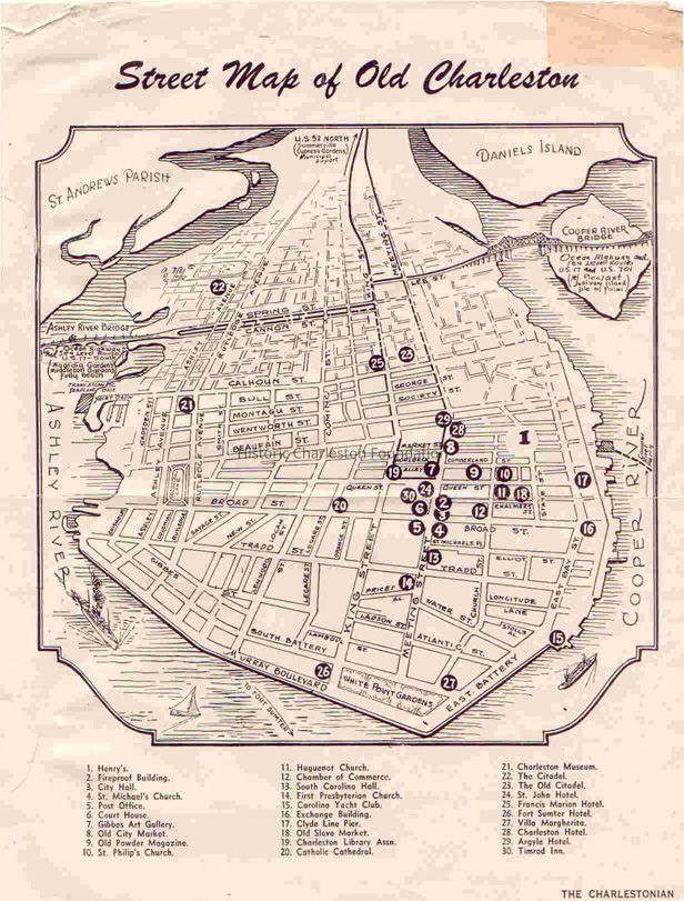
"Street Map of Old Charleston."
Page from the Spring 1951 Tourist Supplement to the Charlestonian, Official Publication of the Chamber of Commerce, Charleston, S.C. (from verso). A map of Charleston with points of interest highlighted and indexed.Collection
HCF Map CollectionAcquisition
Accession
2004.019.Source or Donor
Mr. and Mrs. Whitemarsh S. Smith IIIAcquisition Method
GiftCredit Line
Gift of Whitemarsh Smith IIILexicon
Nomenclature 4.0
Nomenclature Secondary Object Term
MapNomenclature Primary Object Term
CartographNomenclature Sub-Class
Graphic DocumentsNomenclature Class
Documentary ObjectsNomenclature Category
Category 08: Communication ObjectsSearch Terms
Tourist maps, tourist publications, Charleston (S.C.)--Maps, TouristArchive Details
Creator
Charleston Chamber of CommerceDate(s) of Creation
circa 1951Archive Size/Extent
1 map, 8.5" x 11"Archive Notes
Date(s): 1951
Publication Date: 1951
Publisher: Charleston Chamber of CommerceDimensions
Dimension Notes
8.5" x 11"Location
Location
Container
FolderDrawer
Drawer 4Cabinet
Blueprints-Maps 5Room
Margaretta P. Childs ArchivesBuilding
Missroon HouseCategory
PermanentDate
February 7, 2023Location
Building
Missroon Archives/Blueprint-Map CabinetsCategory
PermanentLocation
Drawer
Map DrawerRoom
Margaretta P. Childs ArchivesBuilding
Missroon HouseCategory
PermanentLocation
Container
Folder 2Drawer
Drawer 4Room
Margaretta P. Childs ArchivesBuilding
Missroon HouseCategory
PermanentRelationships
Related Places
Place
Location
Charleston PeninsulaCreated By
admin@catalogit.appCreate Date
March 15, 2004Updated By
admin@catalogit.appUpdate Date
February 17, 2023