Name/Title
King Street (General Information) and King Street Facade Program: Final Record of StudyEntry/Object ID
KING.GEN.001Scope and Content
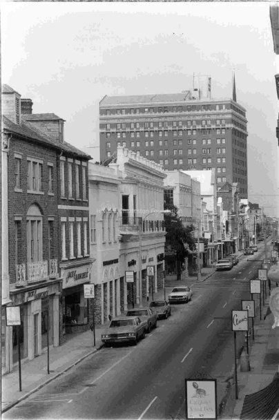
King Street, named for the ruler of England, was in the early days of the settlement the main highway into Charlestown, down the narrow "Neck" from the interior. It followed a ridge of high ground between the many creeks and marshes lacing the peninsula. The road was known variously as "The Broad Path," the "High Way," and "The Broad Road." Those names continued to be applied to that part of the street above Beaufain Street until after the Revolution. During the latter part of the 18th and early part of the 19th centuries, the upper part of King Street became the center of the wagon yard trade. Wagon drivers from the interior there traded country products for store goods. During the period from the mid-19th century to the early 20th century, King Street was a regional retail emporium. King Street ended at South Battery until 1911, when it was extended southward to newly created Murray Boulevard. (Source: Charleston Streets website)
Two file folders that contain newspaper articles (including DYKYC) about issues such as demolition of buildings, revitalization, beautification, Upper King Street, and the "superblock"; miscellaneous images (photocopies); historical research (plats, City Directory pages, maps); report (1988) entitled "An Historical Survey of the Development of Lower King Street From Broad to Wentworth Street" prepared for the Preservation Society for the King Street Merchants' Association by Robert A. Warnock; HCF correspondence from the 1970s relating to beautification; section on the history of King Street from a report by Historic Preservation graduate student; College of Charleston student report "The King Street Riot of 1876"; City of Charleston Design Division Report 04, "New King Street Square" (2014); photograph of 424 King Street (Gene's Electric Service); brief newspaper article about the closing of Morris Sokol Furniture (510 King Street); information about 96 King Street; research report on 609-613 King Street (Lavelle, 2021).Collection
Historic Charleston Foundation Property RecordsAcquisition
Accession
KING.GEN.Source or Donor
King Street (General)Acquisition Method
Collected by StaffLexicon
Search Terms
King Street, Streets--South Carolina--CharlestonArchive Details
Archive Size/Extent
2 File FoldersArchive Notes
Associated Material: City of Charleston, Records Management Division, has microfilmed the large format photos of the King Street facade study that was conducted in the 1980s, which include notations as to what ideally should be done to preserve the historical standard of the structures. (Per info received July 2006.)
Finding Aids: Index to Property Files.
Level of Description: FolderLocation
Location
Shelf
Property File ShelvesRoom
Margaretta P. Childs ArchivesBuilding
Missroon HouseCategory
PermanentDate
February 7, 2023Location
Container
PF Box 49Shelf
Prop File Shelves, Property File ShelvesRoom
Margaretta P. Childs ArchivesBuilding
Missroon HouseCategory
PermanentRelationships
Related Entries
Notes
Related Units of Description: King Street Surveys (KING.GEN.002)
Aerial view of King Street and vicinity, ca. 1990s, KING.412.2.Related Publications
Notes
Graduate student thesis, One-way to two-way street conversions as a preservation and downtown revitalization tool : the case study of upper King street, 2012.002.044
Stockton report, Historic Buildings in the Midtown Project Area: Architectural/Historical Notes, 2008.002.0008General Notes
Note
Notes: See Media link for reprinted photograph of the 500 block of King Street from Our Charleston (P&C book). Shows Morris Sokol Furniture (510 King) and neighboring buildings, probably 506 King, 508 King, 512 King, 514 King, 516 King.
See Media link for information about 501 King Street (Morris Sokol Furniture).Created By
admin@catalogit.appCreate Date
January 12, 2006Updated By
admin@catalogit.appUpdate Date
February 17, 2023