Name/Title
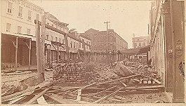
View of Vendue Range Looking West after 1886 EarthquakeEntry/Object ID
VENDUE.GEN.3Description
Photograph of Vendue Range, looking west, after the 1886 earthquake. Destruction debris throughout the street. Wagener-Ohlandt Building (161 East Bay Street) in background.Collection
Historic Charleston Foundation Property RecordsAcquisition
Accession
VENDUE.GEN.Source or Donor
Vendue Range Street (General)Acquisition Method
Collected by StaffLexicon
Nomenclature 4.0
Nomenclature Primary Object Term
PhotographNomenclature Sub-Class
Graphic DocumentsNomenclature Class
Documentary ObjectsNomenclature Category
Category 08: Communication ObjectsSearch Terms
Streets, Vendue Range, Demolished buildings, lost buildings, Historic buildings--South Carolina--Charleston, Streets--South Carolina--Charleston, Lost architecture--South Carolina--Charleston, Earthquake effects, Charleston Earthquake, S.C., 1886Dimensions
Dimension Notes
~7.25" x 4" photo mounted on 8.5" x 6.5" board.Location
Location
Cabinet
Photo File CabinetsRoom
Margaretta P. Childs ArchivesBuilding
Missroon HouseCategory
PermanentDate
February 7, 2023Copyright
Copyright Details
Public domain.Created By
admin@catalogit.appCreate Date
July 13, 2012Updated By
admin@catalogit.appUpdate Date
February 16, 2023