Name/Title
Aerial Views/Photographs: Historic ViewsEntry/Object ID
2009.003.010aDescription
Reprints of nine 8x10 B&W aerial photographs of Charleston:
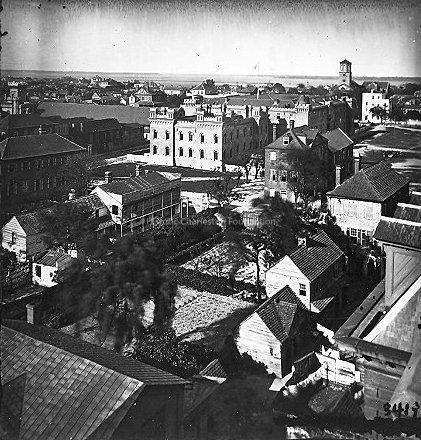
1-2: Looking northeast toward the Cooper River at the edge of the old Citadel, taken from the cupola of the Orphan House, 1865. Library of Congress photograph.
3: Looking east toward the Cooper River. Detroit Photographic Co., ca. 1902.
4: Looking north on Meeting Street. Likely Detroit Photographic Co., late 19th century. (See Photo #9.)
5: Charleston County Courthouse, Blake Tenements, and a row of four similar 18th century tenements facing Meeting Street. Photographic reprint of photo in Charleston in 1883. (Two copies of photo in sleeve.)
6: View of the Charleston County Courthouse from St. Michael's Church taken after the 1883 renovations but before the 1886 earthquake. Patches in the slate roof reveal the location of the 18th century chimney stacks. By 1886 the slate roof had been replaced with a metal one and the four chimneys removed.
7: Looking north on Meeting Street at Chalmers. Franklin Frost Sams, photographer, early 20th century. (See also 2004.021.049.)
8: Aerial view of King Street around John Street, showing King Street facades and the Railroad Complex buildings. King Street is from 438 (the white building with long piazzas) diagonally down to about where Hutson intersects. The 3½ story brick building in the lower right hand corner is still there. The water tower in the upper right is on top of the current Music Hall. Also shows view of the work yards of the buildings that face King and the Warren, and the buildings toward the top of the frame are the Camden sheds between John and Ann. Unattributed, undated (ca. 1920?.) (Negative also in sleeve.)
9: Looking northeast from Washington Square Park in the vicinity of Chalmers Street. St. Philip's Church at upper left, U.S. Custom House in distance. Detroit Photographic Co., late 19th century. (See Photo #4.) (Photographic reprint by William Struhs.)Collection
HCF Image CollectionAcquisition
Accession
2009.003.Source or Donor
New Photos Catalog Records (2009)Acquisition Method
Found in CollectionMade/Created
Time Period
19th Century, 20th CenturyLexicon
Nomenclature 4.0
Nomenclature Primary Object Term
PhotographNomenclature Sub-Class
Graphic DocumentsNomenclature Class
Documentary ObjectsNomenclature Category
Category 08: Communication ObjectsSearch Terms
AerialViews/Photographs, Charleston (S.C.)--Aerial viewsLocation
Location
Container
PhotoBox 12Shelf
AV MaterialsRoom
Margaretta P. Childs ArchivesBuilding
Missroon HouseCategory
PermanentDate
February 7, 2023Relationships
Related Entries
Notes
2004.021.049, 2009.003.010b, 2009.003.010c, 2010.003.003, 2017.003.9a-bRelated Publications
Publication
Buildings of CharlestonNotes
Used to illustrate 29 Chalmers Street.Provenance
Notes
Accumulated by HCF staff.Copyright
Copyright Details
Public domain.General Notes
Note Type
Cataloging NoteNote
Location of Negative: In sleeve with print
Negative No.: 3 41Created By
admin@catalogit.appCreate Date
September 18, 2012Updated By
sferguson@historiccharleston.orgUpdate Date
July 25, 2023