Title
B-L: Biggin Church & Cemetery through LongwoodDescription
Survey sheets and photographs for:
Biggin Church and Cemetery
Blessing
Bossis
Bluff
Bonneau Ferry
Buck Hall
Calais Milestones
Cherry Hill
Comingtee
Cordesville UMC Church
Dean Hall
Emanuel A.M.E. Church
Henry S. Evans House
Exeter
Flagg and Grove Plantations (Amoco property)
Fort Fairlawn
French Quarter Creek
Gippy
James Gourdine House
Halidon Hill/Quinby House
Harry Hill
Jacob Martin Howard House
Huguenot Church Marker (St. Denis Church)
Hyde Park
Irvin Chapel Cemetery
Kensington
Julius Ladson House
Lewisfield (Simons Family Cemetery)
Limerick
LongwoodNotes
Location: Plantation Shelves - CRHD
Container: Box 1Title
M-W: Medway through WappaoolahDescription
Survey sheets and photographs for:
Medway
Mepkin
Middleburg
Naval Weapons Station/Red Bank Road Cottage Plantation
North Chachan
Old Santee
Otranto
Pawley's (plat on Media tab)
Pimlico
Pinopolis Dam/Jeffries Plant
Pompion Hill Chapel (see Media link)
Quinby
Rice Hope (Loutrel Briggs garden)
Richmond
St. Thomas and St. Denis Church (see Media link)
Santee Canal
Silk Hope
Stony Landing
Spring Grove
South Mulberry
Strawberry Chapel/Childsbury Towne
Strawberry Plantation
Taveau Church
Washington
WappoolahNotes
Location: Plantation Shelves - CRHD
Container: Box 2Title
Yeaman's HallDescription
Survey sheets and photographs for Yeaman's Hall Plantation and Yeaman's Hall Graveyard.Container
1-2Notes
Location: Plantation Shelves - CRHD
Container: Box 3Title
CRHD Survey BackgroundDescription
Overview of the survey; bibliographical references; timeline; correspondence.Container
3Notes
Location: Plantation Shelves - CRHD
Container: Box 3Title
CRHD Survey - Contributing SitesDescription
Survey forms for Promised Land M.E. Church; Hagan Plantation; Pimlico; 758 Moultrie Road; Williams House; 1448 Dr. Evans Road; Holy Comforter R.E. Church Cemetery.Container
4Notes
Location: Plantation Shelves - CRHD
Container: Box 3Title
CRHD Survey - "Gone" or Non-Contributing SitesDescription
Survey forms for Moses Chisolm Store; Pimlico Plantation House; Jeremiah Profit House; Julius Cox House; Ropers-McMullen House; St. James Reformed Episcopal Church Cemetery; St. James Reformed Episcopal Church; W.H. Dennis House; and several sites south of SC 41.Container
5Notes
Location: Plantation Shelves - CRHD
Container: Box 3Title
News ArticlesContainer
6Notes
Location: Plantation Shelves - CRHD
Container: Box 3Title
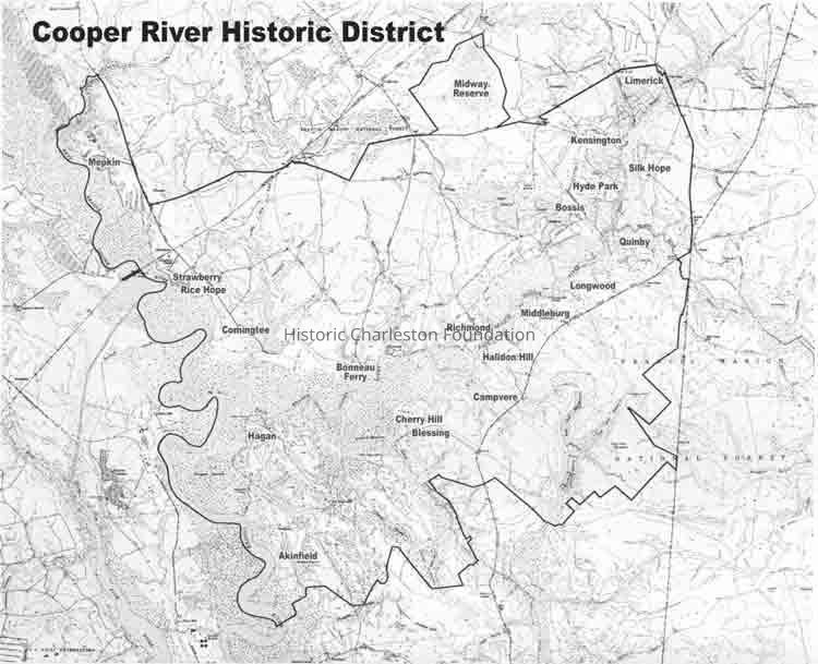
Map with Plantation LocationsContainer
7Notes
Location: Plantation Shelves - CRHD
Container: Box 3Title
Draft - National Register of Historic Places Registration FormContainer
8Notes
Location: Plantation Shelves - CRHD
Container: Box 3Title
National Register of Historic Places Registration FormContainer
9Notes
Location: Plantation Shelves - CRHD
Container: Box 3Title
Photocopies of Photos of the AreaContainer
11Notes
Location: Plantation Shelves - CRHD
Container: Box 3Title
Archaeological Resources of the Proposed Cooper River National Register DistrictDescription
Report by Carl Steen and Ellen Shlasko (Diacrhonic Research Foundation, ca. 1999) for Historic Charleston Foundation. See 2015.002.105.Container
12Notes
Location: Plantation Shelves - CRHD
Container: Box 3Title
SCDAH/SHPO Grant ApplicationDescription
Grant application for the Cooper River Corridor National Register Nomination Survey submitted by Historic Charleston Foundation Jan. 15, 1997Container
10Notes
Location: Plantation Shelves - CRHD
Container: Box 3Title
PhotographsDescription
Photographs and contact sheets (some with corresponding negatives). Some locations identified, some unidentified. Also includes photographs of rice fields (east and west branch) and mile markers. May be duplicates of photos in individual property files.
Locations include: Cypress Gardens, Medway, Middleburg, Mulberry, The Bluff, Taveau Church, Pimlico (typical architecture), Strawberry Chapel, Mepkin Abbey, Pompion Hill, Biggin Church, Cordesville, Rice Hope Plantation, Hyde Park, St. Thomas, Blessing, Yeaman's Hall, Limerick Plantation, Pawley's Plantation, Dean Hall, Longwood, Westvaco, Amoco Mile Marker, Comingtee house and rice mill, Bossis.Notes
Location: Plantation Shelves - CRHD
Container: Box 4