Name/Title
U.S. Coast Survey: Upper Part of Edisto Island and Johossee IslandEntry/Object ID
2007.001.02Scope and Content
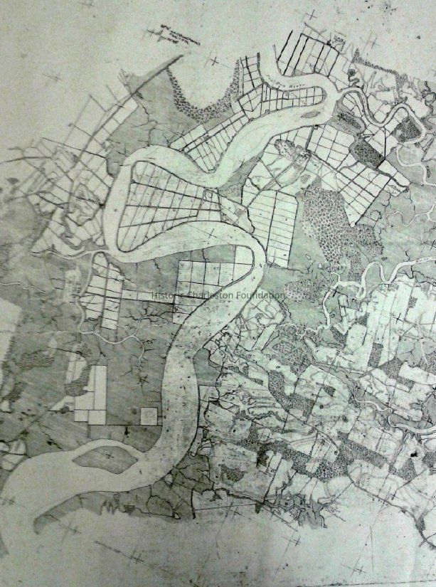
Full title: "U.S. Coast Survey: Upper Part of Edisto Island and Johossee Island, South Carolina, Section V, A.D. Bache Supt, Surveyed in 1856 & 57 by J. Weib."
Photocopy of map of Edisto Island and Jehossee Island.
Scale 1/20,000.
Stamped "No. 679" (may not be original to the map, possibly a library/archives identifier stamp).Collection
HCF Map CollectionAcquisition
Accession
2007.001.Source or Donor
New Archives Catalog Records (2007)Acquisition Method
Collected by StaffLexicon
Nomenclature 4.0
Nomenclature Secondary Object Term
MapNomenclature Primary Object Term
CartographNomenclature Sub-Class
Graphic DocumentsNomenclature Class
Documentary ObjectsNomenclature Category
Category 08: Communication ObjectsSearch Terms
Charleston vicinity maps, Edisto Island (S.C.)--Maps, Jehossee Island (S.C.)--MapsArchive Details
Creator
Seib, J.Date(s) of Creation
1856Archive Size/Extent
1 map (photocopy), 36" x 52"Archive Notes
Date(s) Created: 1856-57 (original)Location
Location
Container
Rolled Doc. Storage BinRoom
Margaretta P. Childs ArchivesBuilding
Missroon HouseCategory
PermanentDate
February 7, 2023Location
Container
Oversize Storage BinRoom
Margaretta P. Childs ArchivesBuilding
Missroon HouseCategory
PermanentGeneral Notes
Note
Notes: Digitized copy of map available at http://alabamamaps.ua.edu/historicalmaps/Coastal%20Survey%20Maps/south%20carolina.htm (Map #679).Created By
admin@catalogit.appCreate Date
May 31, 2007Updated By
admin@catalogit.appUpdate Date
February 17, 2023