Name/Title
West Point Mill RoadEntry/Object ID
2006.007.25Description
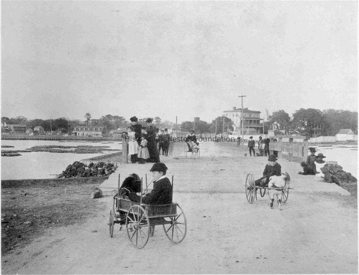
View of the West Point Mill Road. The West Point Rice Mill was located in the area of present-day 14 Lockwood Drive. In this photo, the road approaches the terminus of Calhoun Street at Lucas Street near the Ashley River. The old arsenal buildings of Porter Military Academy can be seen over the rooftops at the left, while to the right is the Jonathan Lucas House. Boys in goat-drawn carts are in the foreground, and adults and children are standing, walking, and seated along the road.Context
From Art Work of Charleston, vol. 6, pg. 1.Collection
HCF Image CollectionAcquisition
Accession
2006.007.Source or Donor
Art Work of CharlestonAcquisition Method
Found in CollectionLexicon
Nomenclature 4.0
Nomenclature Secondary Object Term
Print, PhotographicNomenclature Primary Object Term
PhotographNomenclature Sub-Class
Graphic DocumentsNomenclature Class
Documentary ObjectsNomenclature Category
Category 08: Communication ObjectsLOC Thesaurus for Graphic Materials
Children, Women, Boys, Girls, Men, PeopleSearch Terms
Dirt roads--South Carolina--Charleston, Carts and wagonsLocation
Location
Container
PhotoBox 6Shelf
AV MaterialsRoom
Margaretta P. Childs ArchivesBuilding
Missroon HouseCategory
PermanentDate
February 7, 2023Location
Building
Missroon/Archives/AV MaterialsCategory
PermanentRelationships
Related Entries
Notes
2004.020.121, 2011.022.80a-l, 2011.022.81a-c, 2013.003.15a-c, LOCKWOOD.017.1, LOCKWOOD.017.2, LOCKWOOD.017.3, LOCKWOOD.017.4, LOCKWOOD.017.5 a-f, LOCKWOOD.017.6Copyright
Copyright Details
Public domain.General Notes
Note Type
Cataloging NoteNote
Photograph bound in volume.
Scanned as B&W but actual image is sepia tone.Created By
admin@catalogit.appCreate Date
April 19, 2006Updated By
sferguson@historiccharleston.orgUpdate Date
July 5, 2023