Name/Title
Prioleau Street, Vendue Range, East Battery BuildingsEntry/Object ID
2018.003.17Description
Thirty-six frames (35mm) of B&W photographs of Prioleau Street, Vendue Range, and East Battery. Several views are duplicated. Representative photos are shown in this record.
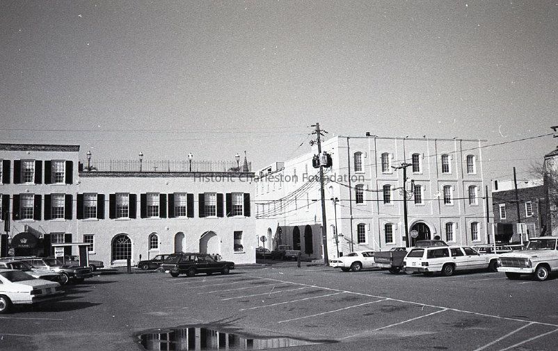
Frames 1-7: View from 35 Prioleau Street (now the Harbour Club) to Vendue Range from the parking lot that was across the street. An archaeological dig by New South Associates was done at the parking lot site in 2000 prior to the construction of the condominium that is there now; the site was referred to as "Parcel A."
Frames 8-10: Rear of Gendron Street elevation of Vendue Range buildings (27-29 Vendue Range) from the parking lot between Prioleau and East Bay Streets.
Frames 11-13: Views of Vendue Range buildings from 15-29 Vendue Range, including The Vendue Hotel.
Frames 14-16: Views 29 East Battery and 31 East Battery. (Print of frame 14 available.)
Frames 17-28: Views looking north on East Battery from 29 East Battery. Shows 29 East Battery, 31 East Battery, 2 Water Street, and beyond. The Missroon House (40 East Battery) can be seen in Frames 19-24. (Print of Frame 19 available.)
Frame 29: View of the southeast corner of the Nathaniel Ingraham House (2 Water Street). Also shows the street corner of East Bay and Water Streets.
Frame 30: View of 25 East Battery, 29 East Battery, and 31 East Battery. (Print available.)
Frames 31-32: View of 29 East Battery.
Frame 33: View north on East Battery from 2 Water Street (left foreground), showing the south elevation of 39 East Bay and the Missroon House (40 East Bay). Also shows the street corner of Water and East Bay Streets.
Frame 34-35: View of 25 East Battery.
Frame 36: View of the south elevation of 29 East Battery before extensive renovations were done.
Negatives dated December 18, 1982. Possibly taken by Historic Charleston Foundation staff.Collection
Historic Charleston Foundation Property RecordsAcquisition
Accession
2018.003Source or Donor
New Photos Catalog Records (2018)Acquisition Method
Found in CollectionMade/Created
Artist
Historic Charleston FoundationDate made
1982Lexicon
Nomenclature 4.0
Nomenclature Secondary Object Term
NegativeNomenclature Primary Object Term
PhotographNomenclature Sub-Class
Graphic DocumentsNomenclature Class
Documentary ObjectsNomenclature Category
Category 08: Communication ObjectsLOC Thesaurus for Graphic Materials
Parking lotsSearch Terms
Prioleau Street, Vendue Range, East Battery, Water Street, Demolished buildings, lost buildings, Street corner, Historic buildings--South Carolina--Charleston, Lost architecture--South Carolina--Charleston, Streets--South Carolina--CharlestonDimensions
Height
3-1/2 inWidth
5 inDimension Notes
Three prints available are 3.5" x 5"Location
Location
Container
See Notes TabCabinet
Photo File CabinetsRoom
Margaretta P. Childs ArchivesBuilding
Missroon HouseCategory
PermanentDate
February 7, 2023Relationships
Related Publications
Notes
Re: Vendue Range/Prioleau photographs, see archaeological report "The Vendue/Prioleau Project: An Archaeological Study of the Early Charleston Waterfront" (obj. ID 2012.002.075).Copyright
Copyright Details
Copyright HCF.General Notes
Note
Notes: Filed (3 prints and negatives) at 29 East Bay Street, photo file cabinet. TIFF files on HiRes036.Created By
admin@catalogit.appCreate Date
November 7, 2018Updated By
admin@catalogit.appUpdate Date
February 17, 2023