Name/Title
Glebe StreetEntry/Object ID
GLEBE.GEN.1Scope and Content
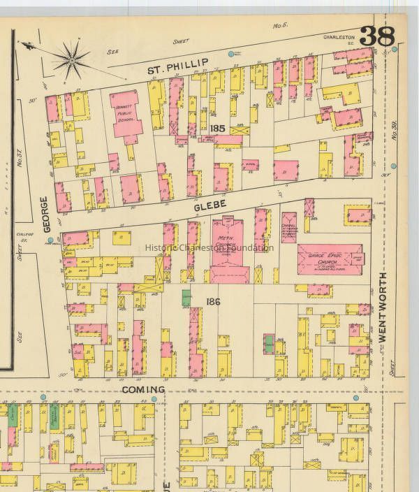
Glebe Street is named for the Glebe Lands, a tract of 17 acres which Affra Harleston Coming gave to the minister of the Church of England in Charles Town, and his successors, in 1698. The Glebe Lands were divided into lots, with a large space reserved for the parsonage of St. Philip's Church, in 1770. The parsonage lot was further subdivided and Glebe Street was cut through the block in 1797. (Source: Information for Guides of Historic Charleston)
File contains page from the Census of Charleston (date not indicated) for Glebe Street.Collection
Historic Charleston Foundation Property RecordsAcquisition
Accession
GLEBE.GEN.Source or Donor
Glebe Street (General)Acquisition Method
Collected by StaffLexicon
Search Terms
Glebe Street, Harleston Village, Streets--South Carolina--CharlestonArchive Details
Archive Size/Extent
1 File FolderArchive Notes
Finding Aids: Index to Property Files
Level of Description: FolderLocation
Location
Shelf
Property File ShelvesRoom
Margaretta P. Childs ArchivesBuilding
Missroon HouseCategory
PermanentDate
February 7, 2023Location
Container
PF BoxShelf
Prop File Shelves, Property File ShelvesRoom
Margaretta P. Childs ArchivesBuilding
Missroon HouseCategory
PermanentLocation
Container
PF Box 44Shelf
Prop File Shelves, Property File ShelvesRoom
Margaretta P. Childs ArchivesBuilding
Missroon HouseCategory
PermanentRelationships
Related Entries
Notes
2014.003.013, GLEBE.009.1a-b, GLEBE.GEN.2a-bGeneral Notes
Note
Notes: Imaged obtained from USC's Digital Collections website, Sanborn Maps.Created By
admin@catalogit.appCreate Date
July 3, 2008Updated By
admin@catalogit.appUpdate Date
February 17, 2023