Name/Title
The City of Charleston, South Carolina [map]Entry/Object ID
2008.001.2Scope and Content
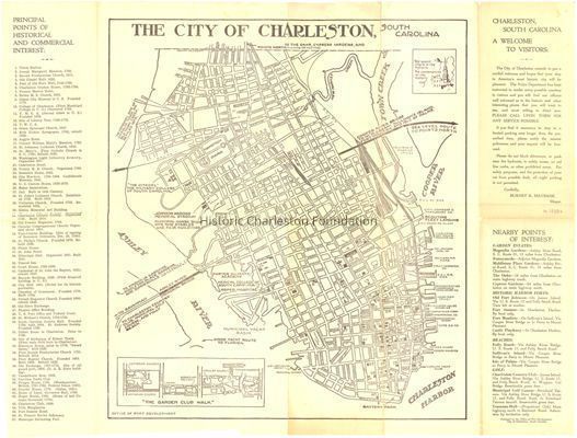
Map of the Charleston peninsula with historic points of interest identified and noted. Includes a welcome to visitors by Mayor Burnet R. Maybank and a map of "The Garden Club Walk" [a/k/a Gateway Walk].
"Released by the Office of Port Development."Collection
HCF Map CollectionAcquisition
Accession
2008.001.Source or Donor
New Archives Catalog Records (2008)Acquisition Method
Collected by StaffLexicon
Nomenclature 4.0
Nomenclature Secondary Object Term
MapNomenclature Primary Object Term
CartographNomenclature Sub-Class
Graphic DocumentsNomenclature Class
Documentary ObjectsNomenclature Category
Category 08: Communication ObjectsSearch Terms
Tourist maps, tourist publications, Lowcountry Digital Library, Charleston (S.C.)--Maps, TouristArchive Details
Creator
City of CharlestonDate(s) of Creation
circa 1930Archive Size/Extent
1 map, 16" x 22"Archive Notes
Date(s): ca. 1930
Publisher: City of Charleston
Place Published: Charleston, SCLocation
Location
Container
FolderDrawer
Drawer 4Cabinet
Blueprints-Maps 5Room
Margaretta P. Childs ArchivesBuilding
Missroon HouseCategory
PermanentDate
February 7, 2023Location
Drawer
Map DrawerRoom
Margaretta P. Childs ArchivesBuilding
Missroon HouseCategory
PermanentLocation
Container
Folder 2Drawer
Drawer 4Room
Margaretta P. Childs ArchivesBuilding
Missroon HouseCategory
PermanentRelationships
Related Places
Place
Location
Charleston PeninsulaGeneral Notes
Note
Notes: The "Garden Club Walk" (a/k/a Gateway Walk) was established by the Garden Club of Charleston in the spring of 1930 to celebrate the 250th anniversary of the founding of Charleston.Created By
admin@catalogit.appCreate Date
August 27, 2008Updated By
admin@catalogit.appUpdate Date
February 17, 2023