Name/Title
The Ichnography of Charles Town at High Water (1739)Entry/Object ID
2008.001.8Scope and Content
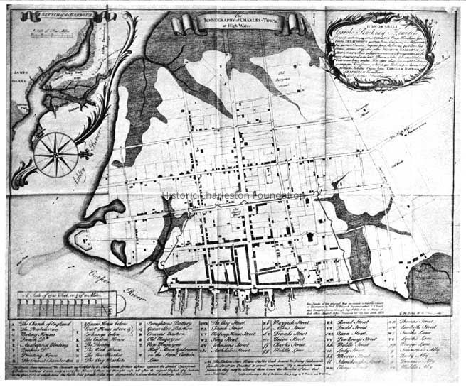
The Ichnography of Charles Town at High Water.
Alternate title: Sketch of the Harbour [Sketch of the Harbor]
Includes dedication statement, index of buildings and streets, and scale.
Reproduced in 1964 by Historic Urban Plans, Ithaca, N.Y. Numbered 473 of an edition limited to 500 copies.Collection
HCF Map CollectionAcquisition
Accession
2008.001.Source or Donor
New Archives Catalog Records (2008)Acquisition Method
Collected by StaffLexicon
Nomenclature 4.0
Nomenclature Secondary Object Term
MapNomenclature Primary Object Term
CartographNomenclature Sub-Class
Graphic DocumentsNomenclature Class
Documentary ObjectsNomenclature Category
Category 08: Communication ObjectsSearch Terms
Historic maps of Charleston, Charleston (S.C.)--MapsArchive Details
Archive Size/Extent
1 map, reproduction, 22" x 17"Archive Notes
Date(s) Created: 1964 reprint; originally published 1739
Date(s): 1739 (date of original)Location
Location
Container
FolderDrawer
Drawer 4Cabinet
Blueprints-Maps 5Room
Margaretta P. Childs ArchivesBuilding
Missroon HouseCategory
PermanentDate
February 7, 2023General Notes
Note
Notes: Copy of original map filed with the poster reproduction.Created By
admin@catalogit.appCreate Date
August 28, 2008Updated By
admin@catalogit.appUpdate Date
February 17, 2023