Name/Title
Herbert Map of 1721 [Fortification Map / Walled City]Entry/Object ID
2008.001.10Scope and Content
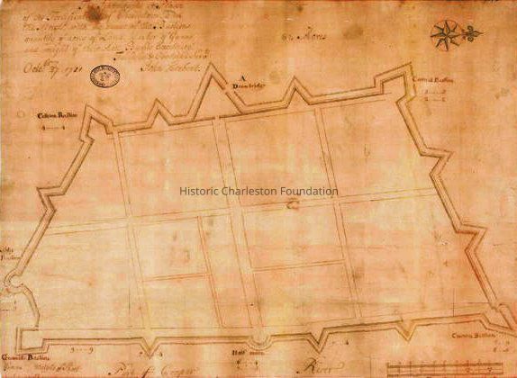
Photographic reprint of the drawing of the original configuration of the fortification wall that surrounded Charles Towne. Original housed in the collection of The British Public Records. Features the Granville Bastion, Half Moon Battery, Craven Bastion, Carteret Bastion, Drawbridge, Colleton Bastion, and Ashley Bastion.
At head of map: "The Ichnography or plann [sic] of the fortifications of Charlestowne, and the streets with the names of the bastions, quantity of acres of land, number of gunns [sic] and weight of their shott [sic]. For his excellency. Faithfull [sic] and obedient son, John Herbert. Octo[ber]27, 1721."
"62 acres."
Stamped "Her Majesty's State Paper Office."Collection
HCF Map CollectionAcquisition
Accession
2008.001.Source or Donor
New Archives Catalog Records (2008)Acquisition Method
Collected by StaffLexicon
Nomenclature 4.0
Nomenclature Secondary Object Term
MapNomenclature Primary Object Term
CartographNomenclature Sub-Class
Graphic DocumentsNomenclature Class
Documentary ObjectsNomenclature Category
Category 08: Communication ObjectsSearch Terms
Historic maps of Charleston, Wall Street, Forts and fortifications--South Carolina--Charleston--Maps, Charleston (S.C.)--MapsArchive Details
Date(s) of Creation
1721Archive Size/Extent
Photographic reprint of map, 15.5" x 11" (2 copies)Archive Notes
Date(s): 1721 (date of original)
Associated Material: Original at British Public Records.Location
Location
Container
FolderDrawer
Drawer 4Cabinet
Blueprints-Maps 5Room
Margaretta P. Childs ArchivesBuilding
Missroon HouseCategory
PermanentDate
February 7, 2023Relationships
Related Entries
Notes
Related Units of Description: Framed print hung near Executive Assistant's office.General Notes
Note
Notes: Two copies of reprint.Created By
admin@catalogit.appCreate Date
August 28, 2008Updated By
admin@catalogit.appUpdate Date
February 17, 2023