Preliminary Study Sheets [Maps]
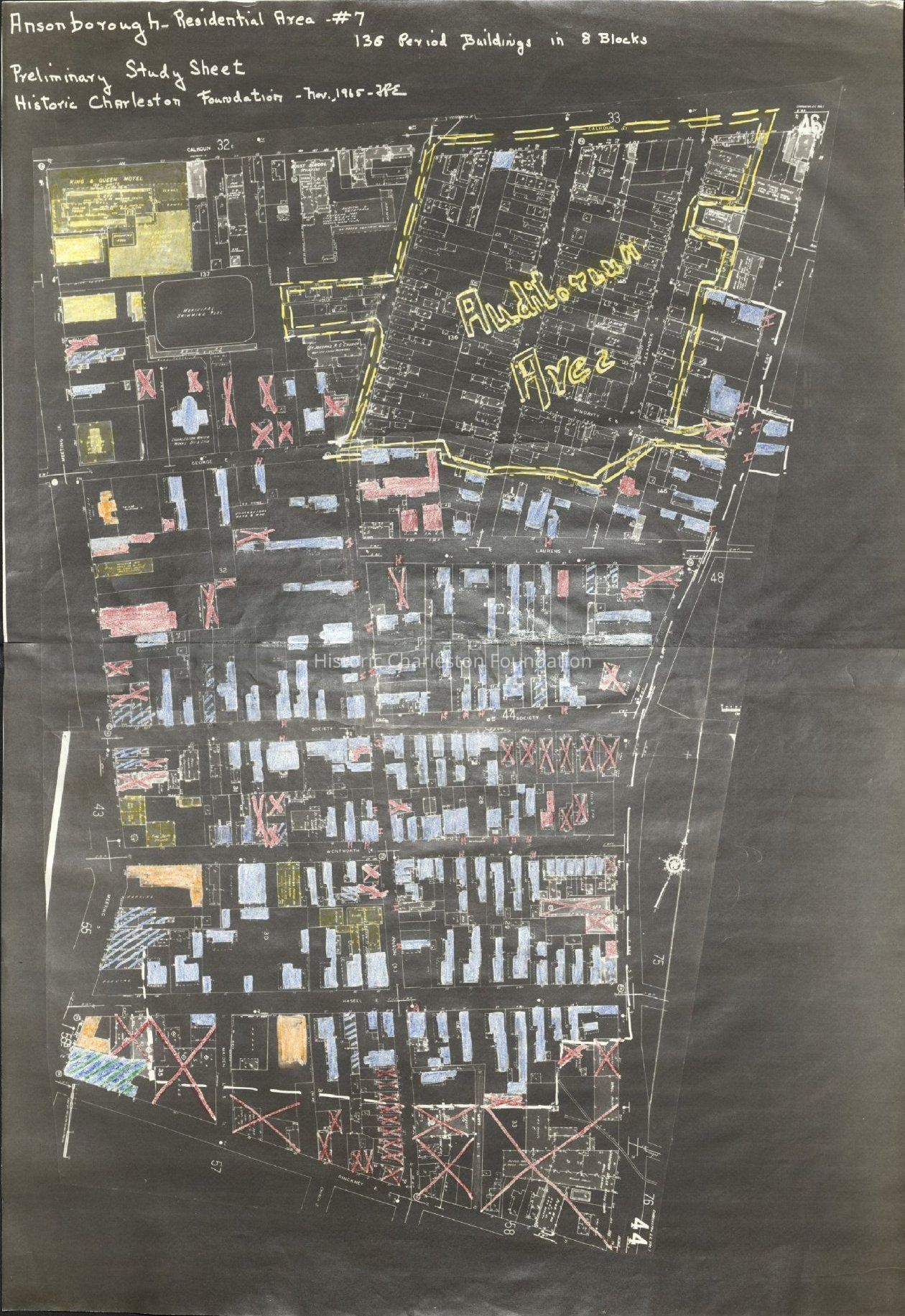
Area Study Map: Ansonborough
Origsize: 26” x 17.5”; Origformat: Document/Photocopy; Resolution: 150 dpi
Name/Title
Preliminary Study Sheets [Maps]Entry/Object ID
2008.001.22Scope and Content
Copies of Sanborn Map pages combined to study maps of various areas in Charleston. Color-coded to depict building status. See image #2 or Media tab for color key. Created by F.R.E. (Frances R. Edmunds) and P.M. (unknown). Area 1: Radcliffeboro residential area (29.5" x 25.5") Area 2: Bennett residential area (20.5" x 17.5") Area 3: Harleston residential area (20" x 20.5") Area 7: Ansonborough residential area (26" x 17.5"), indicating Gaillard Auditorium site Note: Original maps for areas 1, 2, 3, and 7 (mounted on matboard), available. See Related tab. Maps for areas 4, 6, and 8 ("State Street area") (mounted on matboard) available. See HCF.005.10d, e, g.)Collection
HCF Map CollectionAcquisition
Accession
2008.001.Source or Donor
New Archives Catalog Records (2008)Acquisition Method
Collected by StaffLexicon
Nomenclature 4.0
Nomenclature Secondary Object Term
MapNomenclature Primary Object Term
CartographNomenclature Sub-Class
Graphic DocumentsNomenclature Class
Documentary ObjectsNomenclature Category
Category 08: Communication ObjectsSearch Terms
HCF project maps, Ansonborough, Harleston Village, Radcliffeborough and Cannonborough, Gaillard Auditorium, Charleston (S.C.)--Maps, Neighborhoods--South Carolina--CharlestonArchive Details
Date(s) of Creation
1965Archive Size/Extent
4 sheets, various sizesArchive Notes
Date(s): 1965Location
Location
Container
Folder 4Drawer
Drawer 4Cabinet
Blueprints-Maps 5Room
Margaretta P. Childs ArchivesBuilding
Missroon HouseCategory
PermanentDate
February 7, 2023Location
Building
Outgoing LoanDate
September 18, 2014Notes
Reason: Digitization for ARP Exhibit Authorized By: Karen Emmons Notes: Ansonborough Map onlyRelationships
Related Entries
Notes
HCF.005.10a, HCF.005.10b, HCF.005.10c, HCF.005.10f.1-3Exhibitions
Notes
Exhibit Start: 2015-11-1617