Name/Title
Charleston, S.C., and Its Vicinity (1863)Entry/Object ID
2006.001.003Scope and Content
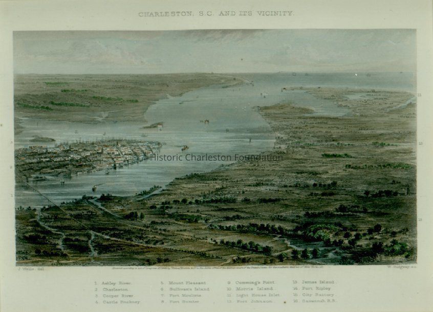
Aerial view of Charleston, S.C., and its vicinity, looking east from land bordering the Ashley River to Mount Pleasant. With key points of interest noted. Steel engraving by J. Wells after drawing by W. Ridgway. Caption underneath illustration: "Entered according to act of Congress 1863, by Virtue, Yorston & Co. in the clerk's office of the district court of the United States for the southern district of N.Y." Points of interest are: Ashley River, Charleston, Cooper River, Castle Pinckney, Mount Pleasant, Sullivan's Island, Fort Moultrie, Fort Sumter, Cumming Point, Morris Island, Light House Inlet, Fort Johnson, James Island, Fort Ripley, City Battery, and Savannah R.R.Collection
Historic Charleston Foundation CollectionAcquisition
Accession
2006.001.Source or Donor
New Archives Catalog Records (2006)Acquisition Method
Collected by StaffLexicon
Nomenclature 4.0
Nomenclature Secondary Object Term
MapNomenclature Primary Object Term
CartographNomenclature Sub-Class
Graphic DocumentsNomenclature Class
Documentary ObjectsNomenclature Category
Category 08: Communication ObjectsSearch Terms
Charleston vicinity maps, Charleston (S.C.)--Maps, Charleston (S.C.)--Aerial viewsArchive Details
Creator
Wells, J.Date(s) of Creation
1863Archive Size/Extent
8.5"x6.75", framed to 16"x15"Archive Notes
Date(s): 1863
Publication Date: 1863Dimensions
Dimension Notes
8.5" x 6.75"Location
Category
PermanentDate
February 7, 2023Relationships
Related Places
Place
Location
West Ashley, Charleston Peninsula, Mount PleasantGeneral Notes
Note
Notes: Cite as: "Charleston, S.C., and its Vicinity," 1863, steel engraving by J. Wells after drawing by W. Ridgway.Created By
admin@catalogit.appCreate Date
February 2, 2006Updated By
admin@catalogit.appUpdate Date
February 16, 2023