Name/Title
City of Charleston Homeowner Initiative Proposed Property Acquisitions: Housing Provider MapEntry/Object ID
2009.001.10Scope and Content
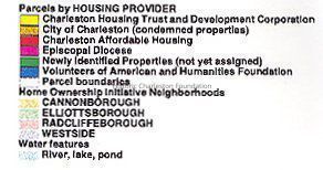
Map of proposed property acquisitions in the Cannonborough, Elliottborough, Radcliffeborough, and West Side neighborhoods. Color-coded to indicate parcels by housing provider, homeownership initiative neighborhoods, and water features.
Housing providers: Charleston Housing Trust and Development Corporation; City of Charleston, Charleston Affordable Housing, Episcopal Diocese, American and Humanities Foundation.Collection
HCF Map CollectionAcquisition
Accession
2009.001.Source or Donor
New Archives Catalog Records (2009)Acquisition Method
Collected by StaffLexicon
Nomenclature 4.0
Nomenclature Secondary Object Term
MapNomenclature Primary Object Term
CartographNomenclature Sub-Class
Graphic DocumentsNomenclature Class
Documentary ObjectsNomenclature Category
Category 08: Communication ObjectsSearch Terms
HCF project maps, Home Ownership Program (HCF Revolving Fund), Elliottborough, Radcliffeborough and Cannonborough, West Side, Charleston (S.C.)--MapsArchive Details
Creator
City of CharlestonDate(s) of Creation
2000Archive Size/Extent
1 map, 22" x 34"Archive Notes
Date(s): 2000Location
Location
Container
Folder 4Drawer
Drawer 4Cabinet
Blueprints-Maps 5Room
Margaretta P. Childs ArchivesBuilding
Missroon HouseCategory
PermanentDate
February 7, 2023Relationships
Related Places
Place
City
CharlestonState/Province
South CarolinaCountry
United States of AmericaGeneral Notes
Note
Notes: Includes logos, presumably for participants: Fair Housing Opens Doors and Community Development.
City of Charleston Geographic Information System map.
HCF member of Charleston Affordable Housing.Created By
admin@catalogit.appCreate Date
July 17, 2009Updated By
admin@catalogit.appUpdate Date
February 16, 2023