Name/Title
1-11 Vendue Range / North Atlantic Wharf Building / Union PierEntry/Object ID
2019.011.2a-cDescription
Three photographs (scans of originals):
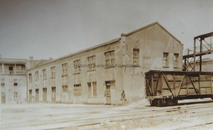
a: View of the commercial buildings that had been located at 1-11 Vendue Range, southeast elevation, ca. 1924. Railroad car in foreground.
b: View of a building on North Atlantic Wharf located by the railroad tracks. Identified as The E.S.T. Co. Offices on the 1902 Sanborn Map. Now the site of the City Gallery. Dated June 4, 1924.
c: Aerial view of Union Pier buildings, looking east, showing two Utilities Commission buildings, the dock, and other unidentified buildings on Concord Street (foreground). Dated April 3, 1925.Collection
HCF Image CollectionAcquisition
Accession
2019.011Source or Donor
Eberle, KevinAcquisition Method
OtherLexicon
Nomenclature 4.0
Nomenclature Primary Object Term
PhotographNomenclature Sub-Class
Graphic DocumentsNomenclature Class
Documentary ObjectsNomenclature Category
Category 08: Communication ObjectsSearch Terms
Lost Architecture, Vendue Range, Demolished buildings, lost buildings, Atlantic Wharf/Mid-Atlantic Wharf/Middle Atlantic Wharf, Commercial buildings--South Carolina--Charleston, Historic buildings--South Carolina--Charleston, Lost architecture--South Carolina--Charleston, Union Pier Terminal (Charleston, S.C.)Location
Category
PermanentDate
February 7, 2023Provenance
Notes
Provided by Kevin Eberle via email on 4/8/2019, who copied the images from eBay. (See Media tab for accompanying email.)Copyright
Copyright Details
Public domain.Created By
admin@catalogit.appCreate Date
April 18, 2019Updated By
admin@catalogit.appUpdate Date
February 16, 2023