Name/Title
An Original Map of Charleston, South Carolina [a/k/a Bridgens and Allen Map]Entry/Object ID
2010.001.03Scope and Content
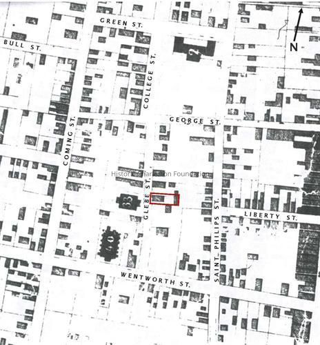
Detailed map showing footprints of houses and buildings, wharves, the Washington Race Course, Magnolia Cemetery, etc. Public buildings noted. Commonly referred to as the "Bridgens and Allen Map" of 1852.Collection
HCF Map CollectionAcquisition
Accession
2010.001.Source or Donor
New Archives Catalog Records (2010)Acquisition Method
Collected by StaffLexicon
Nomenclature 4.0
Nomenclature Secondary Object Term
MapNomenclature Primary Object Term
CartographNomenclature Sub-Class
Graphic DocumentsNomenclature Class
Documentary ObjectsNomenclature Category
Category 08: Communication ObjectsSearch Terms
Historic maps of Charleston, Charleston (S.C.)--Maps, Public buildings--South Carolina--Charleston--MapsArchive Details
Creator
Bridgens, Richard P., Allen, Robert CopelandDate(s) of Creation
1852Archive Size/Extent
1 map (photocopy), ~41" x 52"Archive Notes
Date(s): 1852
Associated Material: Original map at SC Historical Society, #32-120
Publisher: Hayden Brother & Co.
Place Published: CharlestonLocation
Location
Container
RollStorageBox:SeeNotesTubeRoom
Margaretta P. Childs ArchivesBuilding
Missroon HouseCategory
PermanentDate
February 7, 2023Moved By
Karen EmmonsDate
May 29, 14Location
Container
Storage TubeRoom
Margaretta P. Childs ArchivesBuilding
Missroon HouseCategory
PermanentGeneral Notes
Note
Notes: In archival telescoping roll storage box on floor behind rolled storage bin by map cabinets 4-5.
Surveyed by R.P. Bridgens and Robert Allen.
Published by Hayden Brothers & Co.Created By
admin@catalogit.appCreate Date
November 16, 2010Updated By
admin@catalogit.appUpdate Date
February 16, 2023