Name/Title
Queen Street (General)Entry/Object ID
QUEEN.GEN.1Scope and Content
One of the original streets of the Grand Modell, Queen Street was first called Dock Street after a boat dock that was dug in the swamp that then existed at the present intersection of the street with East Bay. Subsequently, it was renamed Queen Street for Caroline of Ansbach, the consort of George II. At its western end, Queen Street ended at a barricade at the present intersection with Smith Street until 1849, when it was extended through the marsh westward to Rutledge Street. At the same time, Smith Street was extended southward from Beaufain to Queen. (Source: 2011 Tour Guide Training Manual)
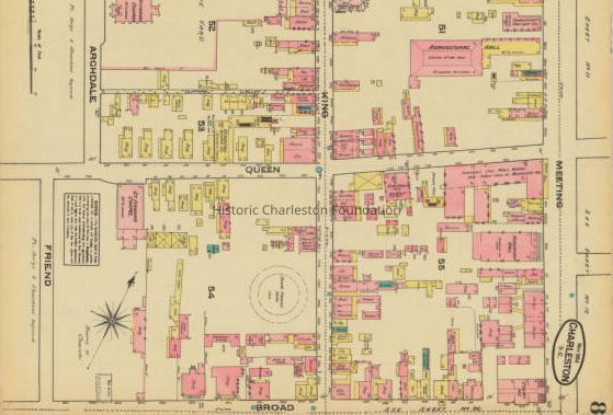
File contains newspaper article (partial 1957 DYKYC) about the cleanup of Queen Street, with mentions of 45 Queen, 19 Queen, 38 Queen, 46 Queen, 50 Queen, 52 Queen, 54 Queen, 45 Queen, 53 Queen; photocopies of Sanborn Map sections (1880, 1884, 1888); photocopy of pages from 1908 city directory listing residents; photocopy of pages from Census (date not indicated) listing residents; photocopy of plat showing lot lying at the west corner of Queen and Union Streets (1800); scan (pdf) of 1849 plat of the west side of Queen Street from Franklin almost to Trapman.Collection
Historic Charleston Foundation Property RecordsAcquisition
Accession
QUEEN.GEN.Source or Donor
Queen Street (General)Acquisition Method
Collected by StaffLexicon
Search Terms
Queen Street, Streets--South Carolina--CharlestonArchive Details
Archive Size/Extent
1 File FolderArchive Notes
Finding Aids: Index to Property Files.
Level of Description: FolderLocation
Location
Building
Missroon/Archives/Property File ShelvesCategory
PermanentDate
February 7, 2023Location
Container
PF Box 84Building
Missroon/Archives/Property File ShelvesCategory
PermanentGeneral Notes
Note
Notes: PDF of 1849 plat on Media link.Created By
admin@catalogit.appCreate Date
August 23, 2011Updated By
admin@catalogit.appUpdate Date
February 17, 2023