Name/Title
Plat of Glebe LandsEntry/Object ID
2014.003.013Description
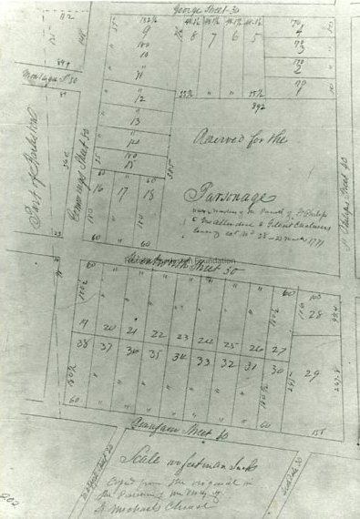
Photographic reprint of a plat of Glebe Lands, bounded by George Street, Cummings [sic] Street [Coming Street], Beaufain Street, and St. Philips [sic] Street [St. Philip Street]. Wentworth Street bisects the area shown in this reprint. Also features the lot reserved for the Parsonage.Context
Original plat from the Charleston Register of of Deeds office; McCrady Plat #202.Collection
Historic Charleston Foundation Property RecordsAcquisition
Accession
2014.003Source or Donor
New Photos Catalog Records (2014)Acquisition Method
Found in CollectionLexicon
Nomenclature 4.0
Nomenclature Tertiary Object Term
PlatNomenclature Secondary Object Term
MapNomenclature Primary Object Term
CartographNomenclature Sub-Class
Graphic DocumentsNomenclature Class
Documentary ObjectsNomenclature Category
Category 08: Communication ObjectsLOC Thesaurus for Graphic Materials
PlatsSearch Terms
Streets, Harleston Village, George Street, Coming Street, Beaufain Street, St. Philip Street, Wentworth Street, Streets--South Carolina--CharlestonLocation
Location
Cabinet
Photo File CabinetsRoom
Margaretta P. Childs ArchivesBuilding
Missroon HouseCategory
PermanentDate
February 7, 2023Relationships
Related Entries
Notes
GLEBE.009.1a-b, GLEBE.GEN.1, GLEBE.GEN.2a-bProvenance
Notes
Plat from the Charleston Register of Mesne Conveyance; McCrady plat #202.Created By
admin@catalogit.appCreate Date
December 10, 2014Updated By
sferguson@historiccharleston.orgUpdate Date
September 7, 2023