Name/Title
Insurance Maps of Charleston, South Carolina, Vol. IEntry/Object ID
2007.002.0037Secondary Title
Sanborn Maps
Description and Utilization of the Sanborn MapDescription
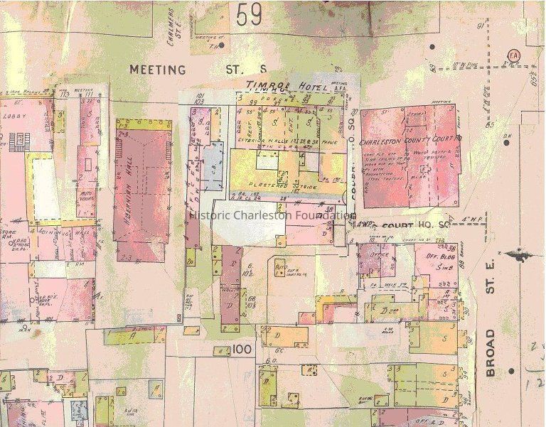
A series of large-scale detailed maps of Charleston that depict the city's commercial, industrial, and residential sections. This volume was published in 1902, with updates, corrections, and addenda through 1953. The maps illustrate the site, size, shape, construction, and building material of dwellings, commercial and public buildings, and factories. Building details include firewalls, location and number of windows and doors, style and composition of roofs, wall thickness, cracks in exterior walls, and numbers of stories. The maps are colored-keyed to identify a building's material composition. The maps also indicate building use; sidewalk and street widths; street layout and names; property boundaries; distance between buildings; house and block numbers; and location of water mains, hydrants, piping, wells, cisterns, and fuel storage tanks. Many buildings are labeled by name, so one can determine where the post office, city hall, dry goods stores, bakeries, etc., were located.
Refer to the accompanying booklet, "Description and Utilization of the Sanborn Map," in Drawer 1, for instructions on how to read the maps and for key to symbols.
Corrections and amendments have been pasted over original maps. See Notes for details.
Cover: 24" wide x 26" high x 3½" deep
91 maps (most col.), 67 cm.
Instruction booklet: 12 p., ill., 28 cm., softcoverCollection
Historic Charleston Foundation LibraryAcquisition
Accession
2007.002.Source or Donor
New Library Catalog Records (2007)Acquisition Method
Found in CollectionLexicon
Nomenclature 4.0
Nomenclature Primary Object Term
BookNomenclature Sub-Class
Other DocumentsNomenclature Class
Documentary ObjectsNomenclature Category
Category 08: Communication ObjectsSearch Terms
Geography, Atlases, Charleston (S.C.)--Maps, Fire insurance maps--South Carolina--CharlestonBook Details
Publisher
Sanborn Map Co.Call No.
G1309 .C52 I57 1902Notes
Date: 1902-1953
Copy No.: 0Location
Date
February 7, 2023Notes
Notes: Disbursed throughout the entire file cabinet. See Finding Aid.Location
Cabinet
Blueprints-Maps 3Room
Margaretta P. Childs ArchivesBuilding
Missroon HouseCategory
PermanentCondition
Overall Condition
FairNotes
Because of previous storage of the volume, the volume had been "beaten up" over time.
Maps are somewhat warped.
Some areas are in need of cleaning and there is evidence (minor) of mold.
Cover has tearing at the spine, water staining, and foxing.Relationships
Related Entries
Notes
2005.002.001, 78.1.2
Volume cover is shelved in archival box created by Wilfred Spoon on Shelf A-7.Related Publications
Notes
Some volumes have been digitized and are available online via both Charleston County Public Library and University of South Carolina.
Available on microfilm at College of Charleston and Charleston County Public Library.
Some institutions (C of C Special Collections, SC Historical Society, Charleston Archives at CCPL) have physical volumes in their collections (access may be limited). (SCHS has vol. 2, 1902.)General Notes
Note
Notes: Updates of maps are pasted over originals; however, often the maps underneath the updates are visible when held up to light.
Inside front cover: Updates/addenda to indexes (pasted in inside front cover) as follows:
Addenda Feb. 1941 to additional index of Feb. 1939
Additional index, Feb. 1951
Addenda Dec. 1953 to additional index of Feb. 1951
Also pasted inside front cover, this notice: "Feb. 1941 correction includes additional territory formerly unmapped, now appearing on sheets 84, 85, and 106."
p. [i]: New Report, Sept. 1952, providing demographic and municipal data, and New Index, March, 1942.
p. [ii]: Additional Indexes: May, 1934, and Feb. 1939 (pasted over Oct. 1935 addenda to May 1934 and Additional Index, Feb. 1938)
p. [iii]: Map of peninsula taped to page, designating ward numbers and boundaries, with note from J.W.D. Zerbst, County Auditor, who presumably added this map into the volume.
p. [iv]: Key map of peninsula; key to symbols (see also booklet); correction record with entries from1942 to 1953.
In 2007, maps were removed from the binding/cover, placed in protective sleeves, and filed in a map cabinet obtained with a Preservation Access Grant awarded by the National Endowment of the Humanities. Book cover retained.
On 8/6/2014, the book cover was transferred to Wilbur Spoon, framer, who will construct an archival storage box and protective cover for.Created By
admin@catalogit.appCreate Date
May 10, 2007Updated By
admin@catalogit.appUpdate Date
February 17, 2023