Name/Title
MapEntry/Object ID
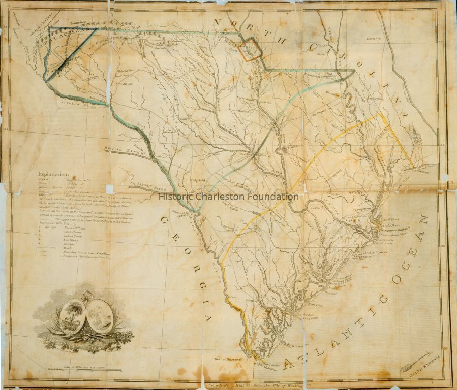
2000.002.001Description
Map of South Carolina including Charleston by T. Coram, 1802. Blue, green, yellow, and red ink were used in the explanation. Colors have now faded.Collection
Historic Charleston Foundation CollectionAcquisition
Accession
2000.002.Source or Donor
Shaver, Ms. EstherAcquisition Method
GiftCredit Line
Edwin and Esther ShaverLexicon
Nomenclature 4.0
Nomenclature Secondary Object Term
MapNomenclature Primary Object Term
CartographNomenclature Sub-Class
Graphic DocumentsNomenclature Class
Documentary ObjectsNomenclature Category
Category 08: Communication ObjectsDimensions
Height
19-1/2 inLength
16-1/2 inDimension Notes
framed:L: 22.5" x W:19.5" X D:1"Location
Location
Room
101ABuilding
Nathaniel Russell HouseCategory
PermanentDate
February 7, 2023Location
Room
101ABuilding
Nathaniel Russell HouseCategory
PermanentMoved By
Sarah FergusonDate
November 3, 2022Location
Room
101ABuilding
Nathaniel Russell HouseCategory
PermanentMoved By
SJDate
July 22, 2004Location
Room
303Building
Nathaniel Russell HouseMoved By
Jill Beute KovermanDate
July 5, 2000Notes
Until: 06/01/2002Location
Room
303Building
Nathaniel Russell HouseMoved By
Jill Beute KovermanDate
July 5, 2000Notes
Until: 06/01/2002Condition
Overall Condition
GoodNotes
Encapsulated and reinforced/backed. Map has been fold: Creases and losses occur along the folds. Edges are worn and torn. Paper has turned yellow. Brown stains are located along edges- particularly the bottom edge.General Notes
Note
Notes: 4" x 5" color transparency in file, before conservation taken by MESDA
conservation treatment slides also in folder, 2000-2001, by Susan NashCreated By
admin@catalogit.appCreate Date
July 8, 2002Updated By
sferguson@historiccharleston.orgUpdate Date
May 1, 2023