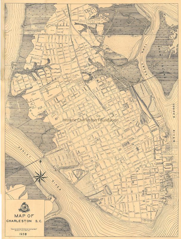
Name/Title
Map of Charleston, S.C. / Map of the City of Charleston, S.C.Entry/Object ID
2015.020.1Scope and Content
Street map of the Charleston peninsula, with northern boundary at just above Moultrie Street, near Belvidere Creek.
Published by Legerton Co., Inc., Charleston, SC.
Scale: 1" = 500'.
Physical Characteristics: 1 map, 15.75" x 20.75", folded to fit inside 4" x 7" coverCollection
HCF Map CollectionAcquisition
Accession
2015.020Source or Donor
Forrester, Catherine H.Acquisition Method
GiftCredit Line
Courtesy of Cathy ForresterLexicon
Nomenclature 4.0
Nomenclature Secondary Object Term
MapNomenclature Primary Object Term
CartographNomenclature Sub-Class
Graphic DocumentsNomenclature Class
Documentary ObjectsNomenclature Category
Category 08: Communication ObjectsSearch Terms
Peninsula maps, Charleston (S.C.)--MapsArchive Details
Creator
Legerton & Co.Date(s) of Creation
1938Archive Size/Extent
1 map, 15.75" x 20.75", folded to fit inside 4" x 7" coverArchive Notes
Publication Date: 1938
Publisher: Legerton and Co.
Place Published: Charleston, SCLocation
Location
Container
FolderDrawer
Drawer 4Cabinet
Blueprints-Maps 5Room
Margaretta P. Childs ArchivesBuilding
Missroon HouseCategory
PermanentDate
February 7, 2023Created By
admin@catalogit.appCreate Date
July 27, 2015Updated By
admin@catalogit.appUpdate Date
February 17, 2023