Name/Title
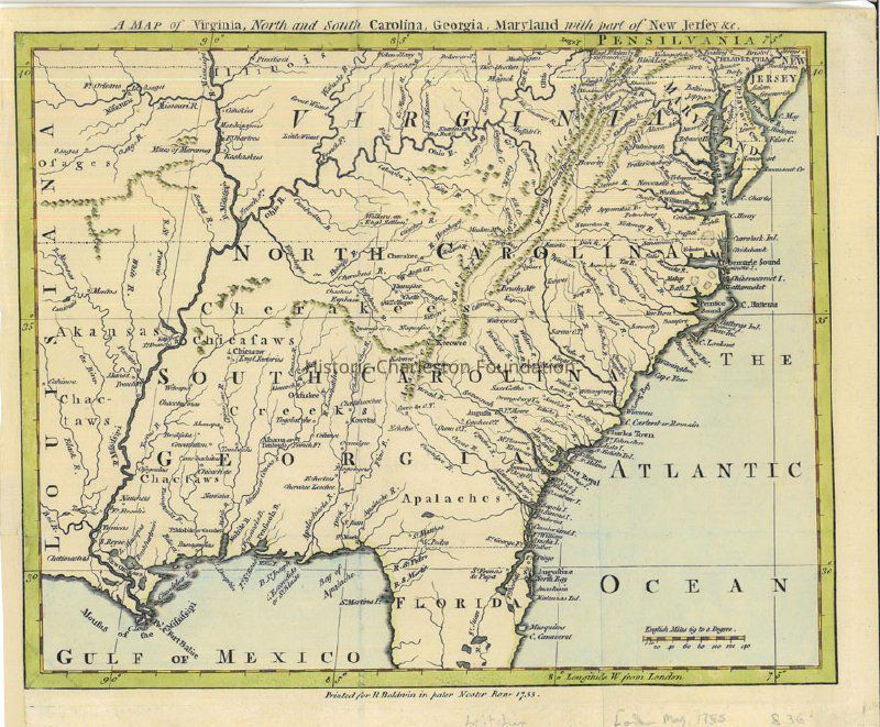
A Map of Virginia, North and South Carolina, Georgia, Maryland, with Part of New Jersey, etc.Entry/Object ID
2005.021.002Scope and Content
Map extends from Cape Canaveral to Philadelphia and westward to the Mississippi. Map shows Native American settlements, including the Cherokee (Cherakees" in western North Carolina). Also shows historical data pertaining to the French and Indian War. Hand-colored.
At bottom: "Printed for R. Baldwin in pater Noster Row 1755."Collection
HCF Image CollectionAcquisition
Accession
2005.021.Source or Donor
Charleton Hall Galleries, Inc.Acquisition Method
PurchasedLexicon
Nomenclature 4.0
Nomenclature Secondary Object Term
MapNomenclature Primary Object Term
CartographNomenclature Sub-Class
Graphic DocumentsNomenclature Class
Documentary ObjectsNomenclature Category
Category 08: Communication ObjectsSearch Terms
South Atlantic States--Maps--Early works to 1800Archive Details
Creator
Baldwin, Richard, 1724-1770Date(s) of Creation
1755Archive Size/Extent
1 map, 11" x 9.5"Archive Notes
Date(s): 1755Location
Location
Container
Misc. Plats & MapsDrawer
Drawer 6Cabinet
Blueprints-Maps 6Room
Margaretta P. Childs ArchivesBuilding
Missroon HouseCategory
PermanentDate
February 7, 2023General Notes
Note
Notes: Map discovered in Archives and cataloged 2/15/2019Created By
admin@catalogit.appCreate Date
February 15, 2019Updated By
sferguson@historiccharleston.orgUpdate Date
April 5, 2023