Name/Title
Map of the Ansonborough Rehabilitation ProjectEntry/Object ID
HCF.005.3B.1Scope and Content
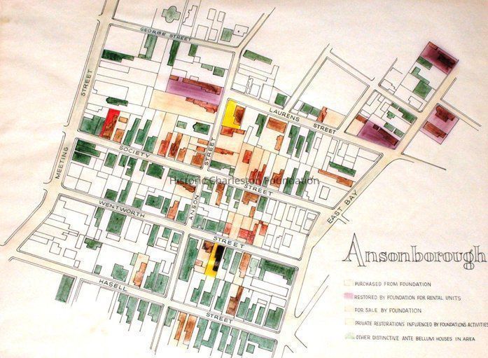
Hand-drawn and color-coded map of Ansonborough indicating properties purchased by HCF, restored by HCF, for sale by HCF, restored privately, and other distinctive antebellum houses. Created to illustrate HCF's Ansonborough Rehabilitation Project.Collection
HCF Map CollectionLexicon
Nomenclature 4.0
Nomenclature Secondary Object Term
MapNomenclature Primary Object Term
CartographNomenclature Sub-Class
Graphic DocumentsNomenclature Class
Documentary ObjectsNomenclature Category
Category 08: Communication ObjectsSearch Terms
Ansonborough, Ansonborough Rehabilitation Project (ARP), Neighborhoods--Conservation and restoration--South Carolina--Charleston, Neighborhood planning--South Carolina--Charleston, Historic preservation--South Carolina--CharlestonArchive Details
Creator
Historic Charleston FoundationArchive Size/Extent
1 sheet, 22.5" x 18"Archive Notes
Date(s) Created: 1960s
Date(s): 1960s
Level of Description: ItemLocation
Location
Drawer
Drawer 2Cabinet
Blueprints-Maps 5Room
Margaretta P. Childs ArchivesBuilding
Missroon HouseCategory
PermanentDate
February 7, 2023Date
September 10, 2014Notes
Reason: Digitization for LCDL & LDHI Exhibit
Authorized By: Karen EmmonsRelationships
Related Entries
Notes
2013.003.04, HCF.005.3A, HCF.005.3B, HCF.005.3B.2, HCF.005.3B.3, HCF.005.3B.4, HCF.005.3B.5, HCF.005.3B.6, HCF.005.3B.7Created By
admin@catalogit.appCreate Date
March 22, 2013Updated By
admin@catalogit.appUpdate Date
February 17, 2023