Name/Title
Plan of Wraggborough on Charleston Neck...Entry/Object ID
2013.001.05Scope and Content
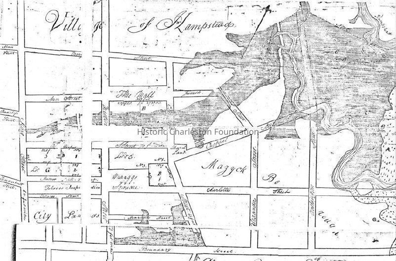
Title of drawing: Plan of Wraggborough on Charleston Neck...
Date of plat: Dec. 18, 1805
Name of creator: Joseph R. Purcell
Shows Village of Hampstead and Mazyckborough and the area bounded by Mary Street, King Street, Boundary Street, and the Cooper River.
Recorded Feb. 15, 1806
From Book Q7, Page 413, RMC.Collection
Historic Charleston Foundation Property RecordsAcquisition
Accession
2013.001.Source or Donor
New Archives Catalog Records (2013)Acquisition Method
Collected by StaffLexicon
Nomenclature 4.0
Nomenclature Tertiary Object Term
PlatNomenclature Secondary Object Term
MapNomenclature Primary Object Term
CartographNomenclature Sub-Class
Graphic DocumentsNomenclature Class
Documentary ObjectsNomenclature Category
Category 08: Communication ObjectsLOC Thesaurus for Graphic Materials
PlatsSearch Terms
Wraggborough, Mazyckborough, Hampstead Village, Charleston NeckArchive Details
Creator
Purcell, Joseph R.Date(s) of Creation
Dec 18, 1805Archive Size/Extent
1 page, 16"x18.5" (photocopy)Archive Notes
Date(s): 1805
Finding Aids: See Finding Aid to Architectural Drawings, Maps, and Plats.
See List of Properties; then locate Cabinet, Drawer, Folder.
Level of Description: ItemLocation
Location
Container
Misc. Plats & MapsDrawer
Drawer 1Cabinet
Blueprints-Maps 6Room
Margaretta P. Childs ArchivesBuilding
Missroon HouseCategory
PermanentDate
February 7, 2023General Notes
Note
Notes: Photocopied in sections and taped together.Created By
admin@catalogit.appCreate Date
April 2, 2013Updated By
admin@catalogit.appUpdate Date
February 16, 2023