Name/Title
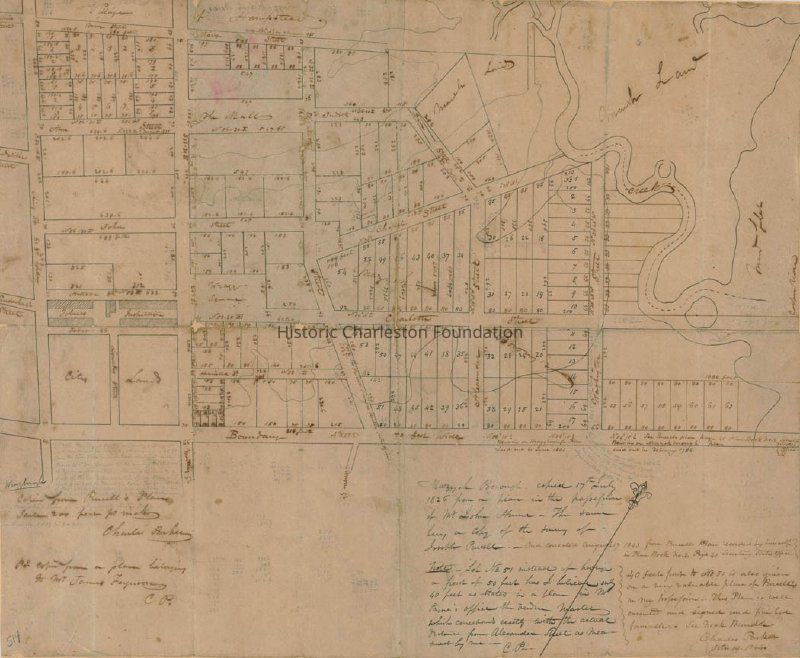
Plan of Wraggborough Situated on Charleston Neck [1859 copy of plat based on original Village of Hampstead plat drawn by Joseph R. Purcell June 1801]Entry/Object ID
2013.001.06Scope and Content
Title of drawing: Plan of Wraggborough Situated on Charleston Neck
Date of plat: June 1801 (original); April 8, 1859 (copy)
Name of creator: White & Ramsey (original by Joseph R. Purcell)
Shows Village of Hampstead and Mazyckborough and the area bounded by Mary Street, King Street, Boundary Street, and the Cooper River.
From McCrady Plat Collection (Charleston County Register of Deeds, MC 0514).Collection
Historic Charleston Foundation Property RecordsAcquisition
Accession
2013.001.Source or Donor
New Archives Catalog Records (2013)Acquisition Method
Collected by StaffLexicon
Nomenclature 4.0
Nomenclature Tertiary Object Term
PlatNomenclature Secondary Object Term
MapNomenclature Primary Object Term
CartographNomenclature Sub-Class
Graphic DocumentsNomenclature Class
Documentary ObjectsNomenclature Category
Category 08: Communication ObjectsLOC Thesaurus for Graphic Materials
PlatsSearch Terms
Wraggborough, Hampstead Village, Mazyckborough, Real property--South Carolina--CharlestonArchive Details
Date(s) of Creation
1801Archive Size/Extent
1 page, 18"x24" (photocopy)Archive Notes
Date(s) Created: 6/1801 (original); 4/8/1859 (copy)
Finding Aids: See Finding Aid to Architectural Drawings, Maps, and Plats.
See List of Properties; then locate Cabinet, Drawer, Folder.
Level of Description: ItemLocation
Location
Container
Misc. Plats & MapsDrawer
Drawer 1Cabinet
Blueprints-Maps 6Room
Margaretta P. Childs ArchivesBuilding
Missroon HouseCategory
PermanentDate
February 7, 2023Relationships
Related Publications
Notes
Plan of Mazyckborough...Laid Out in Lots...Belonging to Alexander Mazyck...from a 1706 Survey. McCrady plat MC0507. (See ROD website.)Created By
admin@catalogit.appCreate Date
April 2, 2013Updated By
admin@catalogit.appUpdate Date
February 17, 2023