Name/Title
Map Showing the Location and Boundaries of the Signiory of St. Giles Community Called Ashley BaronyEntry/Object ID
2013.001.09Scope and Content
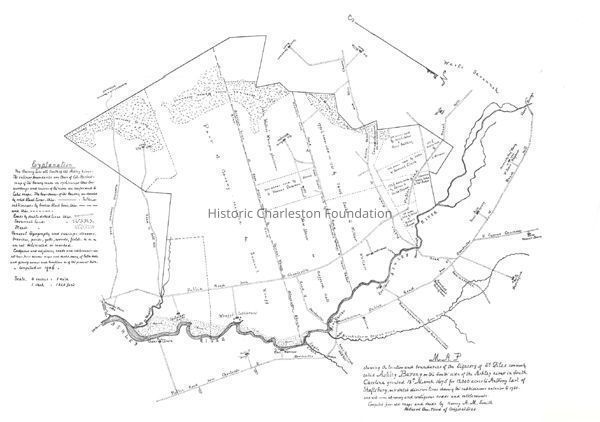
Title of map: Map showing the location and boundaries of the signiory of St. Giles community called Ashley Barony on the south side of the Ashley river in South Carolina granted 18th March 1675 for 12,000 acres to Anthony Earl of Shaftsbury, with sketch division lines showing the subdivisions anterior to 1780 and with some adjoining and contiguous roads and settlements
Creator: Compiled from old maps and deeds by Henry A.M. Smith
Date: Undated
Scale: 4" = 1 mile, 1" = 1320'
Produced one-third of original size.
Map from The Baronies of South Carolina by Henry A.M. Smith.Collection
Historic Charleston Foundation Property RecordsAcquisition
Accession
2013.001.Source or Donor
New Archives Catalog Records (2013)Acquisition Method
Collected by StaffLexicon
Nomenclature 4.0
Nomenclature Secondary Object Term
MapNomenclature Primary Object Term
CartographNomenclature Sub-Class
Graphic DocumentsNomenclature Class
Documentary ObjectsNomenclature Category
Category 08: Communication ObjectsSearch Terms
Charleston vicinity maps, Ashley Barony (S.C.)--MapsArchive Details
Creator
Smith, Henry A. M.Archive Size/Extent
27" x 19"Archive Notes
Date(s) Created: Undated
Date(s): Undated
Finding Aids: See Finding Aid to Architectural Drawings, Maps, and Plats.
See List of Properties; then locate Cabinet, Drawer, Folder.
Level of Description: ItemLocation
Location
Container
FolderDrawer
Drawer 5Cabinet
Blueprints-Maps 6Room
Margaretta P. Childs ArchivesBuilding
Missroon HouseCategory
PermanentDate
February 7, 2023Location
Container
Folder 2Drawer
Drawer 5Room
Margaretta P. Childs ArchivesBuilding
Missroon HouseCategory
PermanentCreated By
admin@catalogit.appCreate Date
April 19, 2013Updated By
admin@catalogit.appUpdate Date
February 17, 2023