Name/Title
Chicora Park General PlanEntry/Object ID
2011.022.28Scope and Content
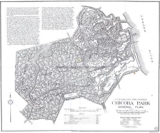
Chicora Park General Plan drawn by the Olmsted Brothers for the City of Charleston Park Commission, April 18, 1899. Includes extensive explanation notes, names of Board of Park Commissioners, descriptions of distances and areas. Published by the Heliotype Printing Co.
Photocopy of map.Collection
HCF Map CollectionAcquisition
Accession
2011.022.Source or Donor
Laurens, JohnAcquisition Method
GiftCredit Line
Gift of John Laurens IIILexicon
Nomenclature 4.0
Nomenclature Secondary Object Term
MapNomenclature Primary Object Term
CartographNomenclature Sub-Class
Graphic DocumentsNomenclature Class
Documentary ObjectsNomenclature Category
Category 08: Communication ObjectsSearch Terms
Charleston vicinity maps, Historic parks--South Carolina--Charleston--MapsArchive Details
Creator
Olmsted BrothersDate(s) of Creation
Apr 18, 1899Archive Size/Extent
1 map, ~18" x 22" (photocopy)Archive Notes
Date(s): 1899Location
Location
Container
Folder 2Drawer
Drawer 5Cabinet
Blueprints-Maps 5Room
Margaretta P. Childs ArchivesBuilding
Missroon HouseCategory
PermanentDate
February 7, 2023Location
Container
Folder 2Drawer
Drawer 5Room
Margaretta P. Childs ArchivesBuilding
Missroon HouseCategory
PermanentGeneral Notes
Note
Notes: Removed from Charleston Navy Yard "Officer Housing" file.
"72" printed in lower right corner.Created By
admin@catalogit.appCreate Date
October 4, 2013Updated By
admin@catalogit.appUpdate Date
February 17, 2023