Buildings and Street Scenes in Charleston and Vicinity, ca. 1940s

a: The Battery & Fort Sumter Hotel, 1940s: Origsize: 2.75x4.5; Origformat: Print-Photographic; Resolution: 75 dpi
a: The Battery & Fort Sumter Hotel, 1940s

Origsize: 2.75x4.5; Origformat: Print-Photographic; Resolution: 75 dpi

Name/Title

Buildings and Street Scenes in Charleston and Vicinity, ca. 1940s

Entry/Object ID

2013.010.06a-s

Tags

Content warning

Description

Nineteen ca. 1940s B&W photographs of buildings and street scenes in Charleston and vicinity. a: Looking west on Murray Boulevard from the bend at East Battery. Edge of White Point Gardens in view at right; Fort Sumter Hotel (now known as the Fort Sumter House at 1 King Street) in background. Cars are on the road. b: Looking north on East Battery Street from near the bend at White Point Gardens. Pedestrian is walking by White Point Gardens. Louis DeSaussure House (1 East Battery) at center; Missroon House (40 East Bay Street) in the distance. c: Looking north on Church Street from Chalmers Street. Features buildings on the west side of the street: 127 Church, 129 Church, 131 Church, and the Dock Street Theater). Also in view are buildings on the east side of the street: 18 Chalmers Street, 132 Church Street, and St. Philip's Church).Cars are parked on the street. d: Looking north on Church Street from the northeast corner of Chalmers Street. Features buildings on the west side of the street: 129 Church, 131 Church, and the Dock Street Theater). Also in view are buildings on the east side of the street: 18 Chalmers Street, 132 Church Street, and St. Philip's Church).Cars are parked on the street. e: View of Market Hall, southwest elevation, including market sheds, and the corner of Market and Meeting Streets. Cars on street and pedestrian crossing the street. Cravens Delco Radio [store] on North Market Street at left. f: Scene on Meeting Street just south of the "Four Corners of Law" on Broad Street. Features the Federal Courthouse and Post Office and St. Michael's Church in foreground, and the County Courthouse and City Hall in background. Numerous cars are parked in front of the Federal Courthouse, with pedestrians on the sidewalk. g: View of the intersection of Broad and Meeting Streets, featuring the Federal Courthouse and Post Office and St. Michael's Church. A car, motorcycle, and bus are on the street the street. Also shows pedestrian activity. h: Looking north on Legare Street at 22 Legare Street (Charles Elliott House), a portion of which can be seen in the foreground (right). Man gathering leaves on the sidewalk. Car parked in background. i: Looking north on Legare Street at 14 Legare Street (Simmons-Edwards House a/k/a Pineapple Gate House), gates in foreground (right). j: View of the Sword Gate (32 Legare Street). k: Looking west on Tradd Street at the outbuildings of 32 Legare Street (Sword Gate House). West End Dairy truck parked on street. Pedestrian on sidewalk and person riding a bike on street. l: 15 Meeting Street (John Edwards House), street (front) elevation. m: Gate of the Robert T. Chisolm House (23 Legare Street), a/k/a Sass Gate. n: Gate to Washington Square Park. Daniel Ravenel House (68 Broad Street) in background. o: Doorway of the Col. John Stuart House (106 Tradd Street). p: Looking west on Broad Street at 110 Broad Street (Bishop Northrop residence a/k/a William Harvey House a/k/a Ralph Izard House) and 114 Broad Street (Col. Thomas Pinckney House). Cars parked along the street. q: Small wooden dwelling, possibly a former slave cabin. r: Small wooden dwelling, possibly a former slave cabin. s: Two wooden structures.

Collection

HCF Image Collection

Acquisition

Accession

2013.010.

Source or Donor

Heckert, Dwayne

Acquisition Method

Gift

Credit Line

Gift of Dwayne Heckert

Made/Created

Artist

Unattributed

Date made

circa 1940 - circa 1949

Inscription/Signature/Marks

Location

back of photograph (q)

Transcription

Negro hut

Location

back of photograph (r)

Transcription

Negro hut near school

Location

back of photograph (s)

Transcription

School etc. on way to Frenchmans(?) house. [Illegible] on right hand corner of building.

Lexicon

Nomenclature 4.0

Nomenclature Primary Object Term
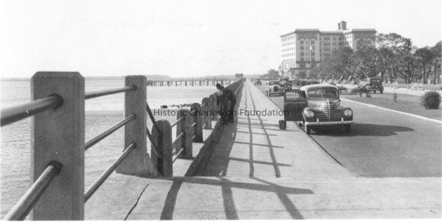
Photograph

Nomenclature Sub-Class

Graphic Documents

Nomenclature Class

Documentary Objects

Nomenclature Category

Category 08: Communication Objects

LOC Thesaurus for Graphic Materials

Pedestrians, Motorcycles, Buses, Gates, Ironwork, Trucks, Doorways

Search Terms

Murray Boulevard, East Battery, Church Street, Market Street, North Market Street, Meeting Street, Broad Street, Legare Street, Tradd Street, Cars, Lowcountry Digital Library, Charleston (S.C.)--Buildings, structures, etc., Dwellings--South Carolina--Charleston, Historic buildings--South Carolina--Charleston, Streets--South Carolina--Charleston, Hotels--South Carolina--Charleston, Fort Sumter Hotel (Charleston, S.C.), White Point Garden (Charleston, S.C.), Battery Park (Charleston, S.C.), Antique and classic cars, St. Philip’s Church (Charleston, S.C.), Dock Street Theater (Charleston, S.C.), Lost architecture--South Carolina--Charleston, Market Hall (Charleston, S.C.), U.S. Post Office and Courthouse (Charleston, S.C.), St. Michael’s Episcopal Church (Charleston, S.C.), Charleston County Courthouse (Charleston, S.C.), Charleston City Hall (S.C.), Bicycle riders, Outbuildings--South Carolina--Charleston, Doors, Wooden-frame buildings--South Carolina--Charleston, African Americans--Housing

Dimensions

Height

2-3/4 in

Width

4-1/2 in

Location

Location

Container

PhotoBox 15

Shelf

AV Materials

Room

Margaretta P. Childs Archives

Building

Missroon House

Category

Permanent

Date

February 7, 2023

Copyright

Copyright Details

In copyright.

Created By

admin@catalogit.app

Create Date

March 22, 2013

Updated By

sferguson@historiccharleston.org

Update Date

September 5, 2023