Name/Title
East Bay Street Historic PlatsEntry/Object ID
EBAY.GEN.3Scope and Content
Six copies of 18th- and early 19th century plats of East Bay Street lots:
a: "A Plan for a Body of Land and Wharves Belonging to Samuel Prioleau Jr. Esq., Situated on East Bay, in Ward No. 3, in the City of Charleston ... from a survey taken in May 1707 by Joseph Purcell." Vicinity of East Bay between Unity Alley and Queen Street. Adjacent wharves and lots belonged to Thomas Cochran (to the south) and Alexander Gillon (to the north). Currently in the vicinity of North Atlantic Wharf, Cordes Street, and Vendue Range. RMC plat 622.
b: Plat showing East Bay Street houses at and just north of Tradd Street. Also features nearby wharves and docks on the Cooper River, including Market Wharf [today South Adger's Wharf], with an elevation of the south front of the row of buildings on the market wharf. Dated June 1793.
c: "A Plan of a Lot of Land on the West Side of East Bay Street ... Ward No. 1, Showing all the Buildings and other Improvements Thereon, Belonging to Thomas Somarsall(?) ..." Surveyed 23 November, 1799, by J. Purcell. also shows a lots belonging to Thomas Pinckney, John McCall, and Daniel Jennings(?).
d: "Plan of a Lot of Land in the City of Charleston Lying on the West Side of East Bay Street and North Side of Unity Alley in Ward No. 2, with the Buildings and Other Improvements Thereon Belonging to John McCrady Esq., from a Survey Taken in October 1800 by Joseph Purcell." Copied January(?) 17th 1866. RMC Plat 3341. Shows Unity Alley and the location of Cordes Street.
e: Plat of East Bay Street lots, mostly illegible. One boundary lists John Beal. RMC Plat 3375.
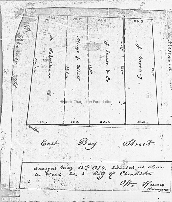
f: Plat of East Bay Street lots "situated as above in Ward No. 3," bounded by the Pinckney and Pritchard lots. Surveyed May 12th 1814, by Wm. Hume.Collection
Historic Charleston Foundation Property RecordsAcquisition
Accession
EBAY.GEN.Source or Donor
East Bay Street (General)Acquisition Method
Collected by StaffLexicon
Nomenclature 4.0
Nomenclature Tertiary Object Term
PlatNomenclature Secondary Object Term
MapNomenclature Primary Object Term
CartographNomenclature Sub-Class
Graphic DocumentsNomenclature Class
Documentary ObjectsNomenclature Category
Category 08: Communication ObjectsLOC Thesaurus for Graphic Materials
PlatsSearch Terms
East Bay Street, Streets-South Carolina--CharlestonArchive Details
Archive Size/Extent
a: 13" x 20" (on 17" x 24" paper)
b: 10.5" x 13.75" (on 17" x 24" paper)
c: 12.5" x 8.5" (on 17" x 24" paper)
d: 13" x 9" (on 17" x 24" paper)
e: 9.5" x 8" (on 11.5" x 17" paper)
f: 14.25" x 7" (on 17" x 24" paper)
g: 6" x 7" (on 11.5" x 17" paper)Archive Notes
Date(s) Created: Various
Date(s): Various
Finding Aids: See Finding Aid to Architectural Drawings, Maps, and Plats.
See List of Properties; then locate Cabinet, Drawer, Folder.
Level of Description: ItemLocation
Location
Container
Misc. Plats & MapsDrawer
Drawer 1Cabinet
Blueprints-Maps 6Room
Margaretta P. Childs ArchivesBuilding
Missroon HouseCategory
PermanentDate
February 7, 2023General Notes
Note
Notes: Copy of RMC Plat 6988 discarded, copy illegible.Created By
admin@catalogit.appCreate Date
November 6, 2014Updated By
admin@catalogit.appUpdate Date
February 17, 2023