Name/Title
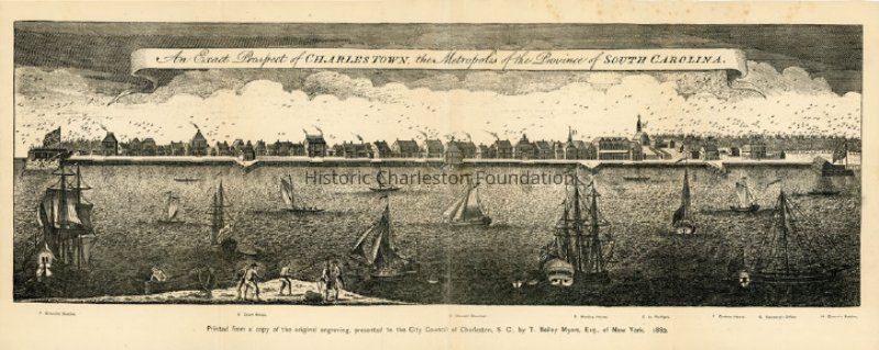
An Exact Prospect of Charles Town, the Metropolis of the Province of South CarolinaEntry/Object ID
2015.001.4Scope and Content
Reprint of an original engraving that was based on Bishop Roberts ca. 1739 painting, "View of Charleston." Illustrates the city of Charleston (then called Charles Town) and the Charleston Harbor as it appeared in the late 1730s, depicting many of the public and private buildings that were destroyed by fire in 1740. Granville Bastion, Court House, Council Chambers, Meeting House, St. Philip's, Custom House, Secretary's Office, and Craven's Bastion are noted as points of interest.Collection
HCF Map CollectionAcquisition
Accession
2015.001Source or Donor
New Archives Catalog Records (2015)Acquisition Method
Collected by StaffLexicon
Nomenclature 4.0
Nomenclature Tertiary Object Term
EngravingNomenclature Secondary Object Term
Print, IntaglioNomenclature Primary Object Term
PrintNomenclature Sub-Class
Graphic DocumentsNomenclature Class
Documentary ObjectsNomenclature Category
Category 08: Communication ObjectsLOC Thesaurus for Graphic Materials
Ships, Sailing shipsSearch Terms
Historic maps of Charleston, Charleston (S.C.)--MapsArchive Details
Archive Size/Extent
1 map, 20.5" x 8.25" x 45" (had been folded to 5.25" x 8.25" to fit within book)Archive Notes
Date(s): 1739 (original view), 1882Location
Location
Container
Oversize Box 1Shelf
Archives D-7Room
Margaretta P. Childs ArchivesBuilding
Missroon HouseCategory
PermanentDate
February 7, 2023Location
Container
Folder 1Drawer
Drawer 4Room
Margaretta P. Childs ArchivesBuilding
Missroon HouseCategory
PermanentGeneral Notes
Note
Notes: Removed from the 1882 City Yearbook, between pp. 340-341.
"Printed from a copy of the original engraving, presented to the City Council of Charleston, S.C., by T. Bailey Myers, Esq., of New York, 1882."Created By
admin@catalogit.appCreate Date
October 21, 2015Updated By
admin@catalogit.appUpdate Date
February 17, 2023