Name/Title
Horlbeck Alley Area / Area in Vicinity of Ashley Hall [Preliminary Study Sheets] [Maps]Entry/Object ID
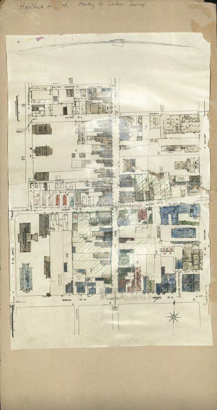
HCF.005.10j-kScope and Content
Copy of two Sanborn Maps color-coded for use by Historic Charleston Foundation to study two areas.
Map j: Area bounded by Horlbeck Alley, Meeting Street, Broad Street, and Legare Street.
Map k: Area in the vicinity of Ashley Hall and vicinity (area by Morris Street, Coming Street, Calhoun Street and Smith Street).
Color-coding depicts building status and condition; color key not provided. Maps affixed to front and back of matboard.
Creator and date not indicated but presumed to be Frances R. Edmunds, 1965.Collection
HCF Map CollectionAcquisition
Accession
HCF.Source or Donor
HCF Institutional RecordsAcquisition Method
Collected by StaffLexicon
Nomenclature 4.0
Nomenclature Secondary Object Term
MapNomenclature Primary Object Term
CartographNomenclature Sub-Class
Graphic DocumentsNomenclature Class
Documentary ObjectsNomenclature Category
Category 08: Communication ObjectsSearch Terms
HCF project maps, Charleston (S.C.)--Maps, Neighborhoods--South Carolina--CharlestonArchive Details
Creator
Edmunds, Frances R.Date(s) of Creation
1965Archive Size/Extent
Photocopy of maps mounted on matboard, 12" x 24"Archive Notes
Date(s): 1965
Level of Description: ItemLocation
Location
Container
Oversize Box 9Shelf
Top of Archives A/BRoom
Margaretta P. Childs ArchivesBuilding
Missroon HouseCategory
PermanentDate
February 7, 2023Exhibitions
Notes
Exhibit Start: 2015-11-16Created By
admin@catalogit.appCreate Date
July 12, 2017Updated By
admin@catalogit.appUpdate Date
February 16, 2023