Name/Title
Ansonborough: Properties Owned by Historic Charleston Foundation [Map]Entry/Object ID
HCF.005.3B.7Scope and Content
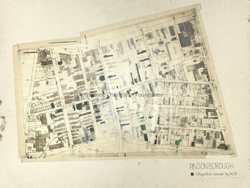
Copy of a Sanborn Map showing Ansonborough, color-coded to indicate properties owned by Historic Charleston Foundation.
See similar maps at HCF.005.3B.3.Collection
HCF Map CollectionLexicon
Nomenclature 4.0
Nomenclature Secondary Object Term
MapNomenclature Primary Object Term
CartographNomenclature Sub-Class
Graphic DocumentsNomenclature Class
Documentary ObjectsNomenclature Category
Category 08: Communication ObjectsSearch Terms
Ansonborough, Ansonborough Rehabilitation Project (ARP), HCF project maps, Charleston (S.C.)--Maps, Neighborhoods--South Carolina--CharlestonArchive Details
Creator
Historic Charleston FoundationDate(s) of Creation
circa 1965Archive Size/Extent
1 map mounted on matboard, 27.75" x 22"Archive Notes
Date(s): ca. 1965
Level of Description: ItemLocation
Location
Drawer
Drawer 2Cabinet
Blueprints-Maps 5Room
Margaretta P. Childs ArchivesBuilding
Missroon HouseCategory
PermanentDate
February 7, 2023Relationships
Related Entries
Notes
2013.003.04, HCF.005.3A, HCF.005.3B, HCF.005.3B.1, HCF.005.3B.2, HCF.005.3B.3, HCF.005.3B.4, HCF.005.3B.5, HCF.005.3B.6Created By
admin@catalogit.appCreate Date
July 12, 2017Updated By
admin@catalogit.appUpdate Date
February 16, 2023