Name/Title
Waccamaw Neck Area Plantation Map, Pee Dee River RegionEntry/Object ID
2018.001.1Scope and Content
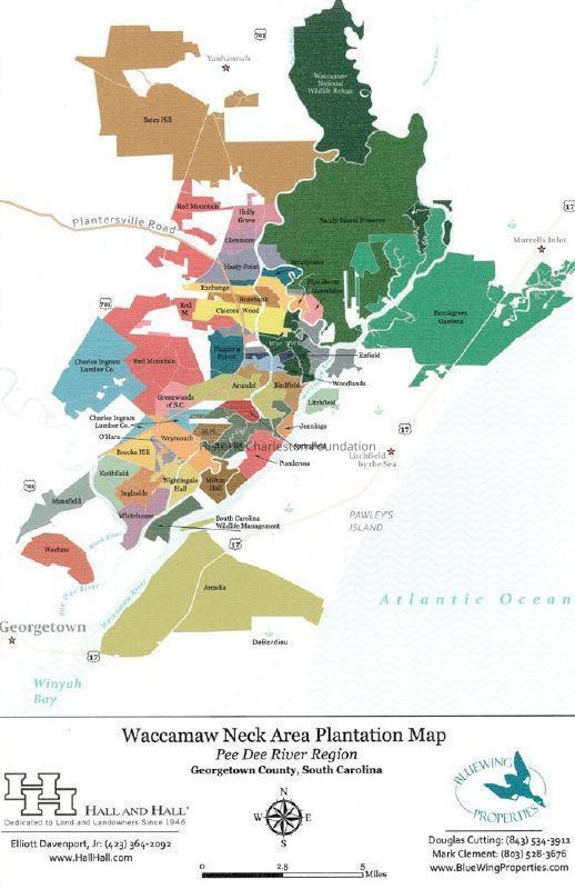
Title: Waccamaw Neck Area Plantation Map: Pee Dee River Region, Georgetown County, South Carolina
Date of map: Undated; sent to HCF 10/16/2018
Name of creator: Hall & Hall and Bluewing Properties
Map of the Pee Dee River region (Georgetown County) showing. by color, the plantations in the Waccamaw Neck area, including
Chicora Wood, Mansfield, Litchfield, Arundel, Whitehouse, and many others.Collection
Historic Charleston Foundation ArchivesLexicon
Nomenclature 4.0
Nomenclature Secondary Object Term
MapNomenclature Primary Object Term
CartographNomenclature Sub-Class
Graphic DocumentsNomenclature Class
Documentary ObjectsNomenclature Category
Category 08: Communication ObjectsSearch Terms
Plantations--Georgetown County--South Carolina--MapsArchive Details
Date(s) of Creation
2018Archive Size/Extent
1 color map on canvas; 11" x 17"Archive Notes
Date(s): 2018
Finding Aids: See Finding Aid to Architectural Drawings, Maps, and Plats.
See List of Properties; then locate Cabinet, Drawer, Folder.
Level of Description: ItemLocation
Location
Container
Misc. Plats & MapsDrawer
Drawer 1Cabinet
Blueprints-Maps 6Room
Margaretta P. Childs ArchivesBuilding
Missroon HouseCategory
PermanentDate
February 7, 2023General Notes
Note
Notes: Sent to Winslow Hastie 10/16/2018 from Elliott Davenport, Hall & Hall landbroker. See Media tab.Created By
admin@catalogit.appCreate Date
November 15, 2018Updated By
admin@catalogit.appUpdate Date
February 17, 2023